You are here: Home > Network List > US - United States National Seismic Network Stations List
> Station MSO Missoula, Montana, USA > Earthquake Result Viewer
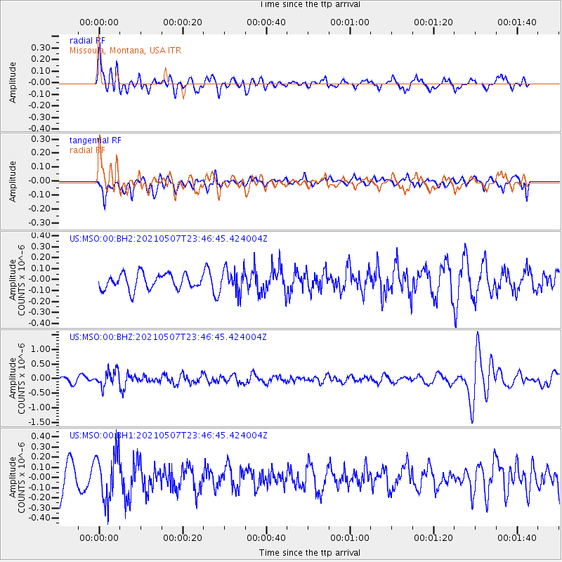
MSO Missoula, Montana, USA - Earthquake Result Viewer
*The percent match for this event was below the threshold and hence no stack was calculated.
| Earthquake location: |
Fiji Islands Region |
| Earthquake latitude/longitude: |
-18.8/-177.5 |
| Earthquake time(UTC): |
2021/05/07 (127) 23:35:14 GMT |
| Earthquake Depth: |
384 km |
| Earthquake Magnitude: |
6.1 Mww |
| Earthquake Catalog/Contributor: |
NEIC PDE/us |
|
| Network: |
US United States National Seismic Network |
| Station: |
MSO Missoula, Montana, USA |
| Lat/Lon: |
46.83 N/113.94 W |
| Elevation: |
1264 m |
|
| Distance: |
86.8 deg |
| Az: |
38.004 deg |
| Baz: |
238.15 deg |
| Ray Param: |
$rayparam |
*The percent match for this event was below the threshold and hence was not used in the summary stack. |
|
| Radial Match: |
63.354942 % |
| Radial Bump: |
397 |
| Transverse Match: |
28.592985 % |
| Transverse Bump: |
364 |
| SOD ConfigId: |
24844331 |
| Insert Time: |
2021-05-22 00:00:07.421 +0000 |
| GWidth: |
2.5 |
| Max Bumps: |
400 |
| Tol: |
0.001 |
|
Signal To Noise
| Channel | StoN | STA | LTA |
| US:MSO:00:BHZ:20210507T23:46:45.424004Z | 3.3328273 | 2.6789317E-7 | 8.038016E-8 |
| US:MSO:00:BH1:20210507T23:46:45.424004Z | 1.4456203 | 2.3269212E-7 | 1.6096351E-7 |
| US:MSO:00:BH2:20210507T23:46:45.424004Z | 1.5423373 | 1.0774319E-7 | 6.985709E-8 |
| Arrivals |
| Ps | |
| PpPs | |
| PsPs/PpSs | |


