You are here: Home > Network List > TX - Texas Seismological Network Stations List
> Station CRHG Carthage > Earthquake Result Viewer
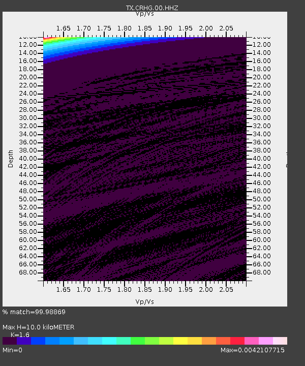
CRHG Carthage - Earthquake Result Viewer
| Earthquake location: |
Fiji Islands Region |
| Earthquake latitude/longitude: |
-16.5/-177.4 |
| Earthquake time(UTC): |
2021/05/11 (131) 09:21:10 GMT |
| Earthquake Depth: |
10 km |
| Earthquake Magnitude: |
5.7 mww |
| Earthquake Catalog/Contributor: |
NEIC PDE/us |
|
| Network: |
TX Texas Seismological Network |
| Station: |
CRHG Carthage |
| Lat/Lon: |
32.29 N/94.23 W |
| Elevation: |
95 m |
|
| Distance: |
93.1 deg |
| Az: |
57.383 deg |
| Baz: |
252.587 deg |
| Ray Param: |
0.041338492 |
| Estimated Moho Depth: |
10.0 km |
| Estimated Crust Vp/Vs: |
1.60 |
| Assumed Crust Vp: |
6.245 km/s |
| Estimated Crust Vs: |
3.903 km/s |
| Estimated Crust Poisson's Ratio: |
0.18 |
|
| Radial Match: |
99.98869 % |
| Radial Bump: |
2 |
| Transverse Match: |
99.98844 % |
| Transverse Bump: |
2 |
| SOD ConfigId: |
24844331 |
| Insert Time: |
2021-05-25 09:36:53.288 +0000 |
| GWidth: |
2.5 |
| Max Bumps: |
400 |
| Tol: |
0.001 |
|

Signal To Noise
| Channel | StoN | STA | LTA |
| TX:CRHG:00:HHZ:20210511T09:33:52.61002Z | 0.11376662 | 1.0472126E-4 | 9.2049193E-4 |
| TX:CRHG:00:HH1:20210511T09:33:52.61002Z | 0.35966527 | 9.835809E-7 | 2.7347119E-6 |
| TX:CRHG:00:HH2:20210511T09:33:52.61002Z | 0.11339739 | 1.4921823E-4 | 0.0013158878 |
| Arrivals |
| Ps | 1.0 SECOND |
| PpPs | 4.1 SECOND |
| PsPs/PpSs | 5.1 SECOND |


