You are here: Home > Network List > WY - Yellowstone Wyoming Seismic Network Stations List
> Station YEE East Entrance, YNP, WY, USA > Earthquake Result Viewer
YEE East Entrance, YNP, WY, USA - Earthquake Result Viewer
| Earthquake location: |
Fiji Islands Region |
| Earthquake latitude/longitude: |
-16.5/-177.4 |
| Earthquake time(UTC): |
2021/05/11 (131) 09:21:10 GMT |
| Earthquake Depth: |
10 km |
| Earthquake Magnitude: |
5.7 mww |
| Earthquake Catalog/Contributor: |
NEIC PDE/us |
|
| Network: |
WY Yellowstone Wyoming Seismic Network |
| Station: |
YEE East Entrance, YNP, WY, USA |
| Lat/Lon: |
44.49 N/109.90 W |
| Elevation: |
2270 m |
|
| Distance: |
86.2 deg |
| Az: |
41.526 deg |
| Baz: |
242.71 deg |
| Ray Param: |
0.044193152 |
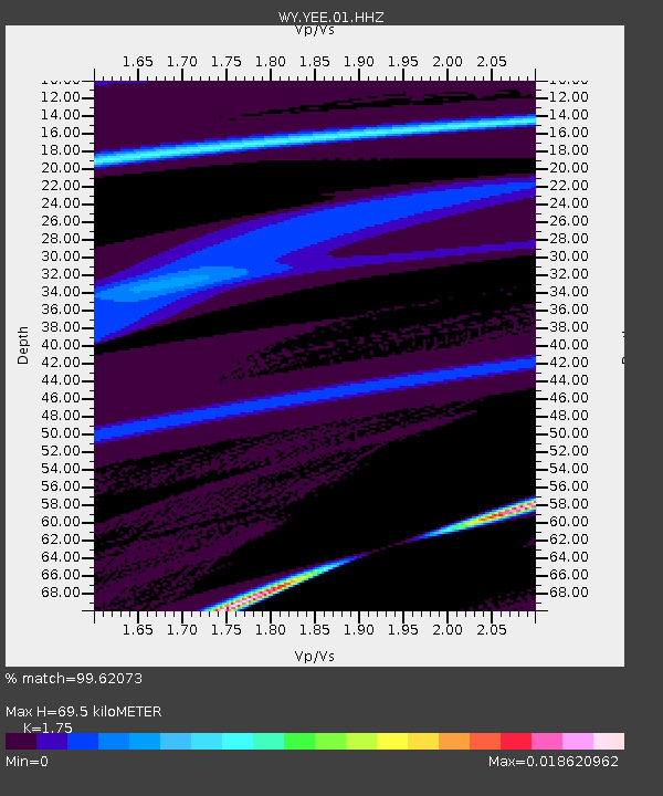
| Estimated Moho Depth: |
69.5 km |
| Estimated Crust Vp/Vs: |
1.75 |
| Assumed Crust Vp: |
6.242 km/s |
| Estimated Crust Vs: |
3.567 km/s |
| Estimated Crust Poisson's Ratio: |
0.26 |
|
| Radial Match: |
99.62073 % |
| Radial Bump: |
24 |
| Transverse Match: |
99.987015 % |
| Transverse Bump: |
3 |
| SOD ConfigId: |
24844331 |
| Insert Time: |
2021-05-25 09:39:08.451 +0000 |
| GWidth: |
2.5 |
| Max Bumps: |
400 |
| Tol: |
0.001 |
|

Signal To Noise
| Channel | StoN | STA | LTA |
| WY:YEE:01:HHZ:20210511T09:33:20.499973Z | 2.6305265 | 1.476258E-7 | 5.6120246E-8 |
| WY:YEE:01:HHN:20210511T09:33:20.499973Z | 2.6387508 | 1.8064995E-7 | 6.84604E-8 |
| WY:YEE:01:HHE:20210511T09:33:20.499973Z | 0.7573191 | 2.9194558E-9 | 3.854988E-9 |
| Arrivals |
| Ps | 8.5 SECOND |
| PpPs | 30 SECOND |
| PsPs/PpSs | 38 SECOND |


