You are here: Home > Network List > AV - Alaska Volcano Observatory Stations List
> Station MAPS Pakushin Southeast, Makushin Volcano, Alaska > Earthquake Result Viewer
MAPS Pakushin Southeast, Makushin Volcano, Alaska - Earthquake Result Viewer
| Earthquake location: |
New Britain Region, P.N.G. |
| Earthquake latitude/longitude: |
-5.4/151.0 |
| Earthquake time(UTC): |
2021/05/11 (131) 15:27:34 GMT |
| Earthquake Depth: |
106 km |
| Earthquake Magnitude: |
5.4 Mww |
| Earthquake Catalog/Contributor: |
NEIC PDE/us |
|
| Network: |
AV Alaska Volcano Observatory |
| Station: |
MAPS Pakushin Southeast, Makushin Volcano, Alaska |
| Lat/Lon: |
53.81 N/166.94 W |
| Elevation: |
333 m |
|
| Distance: |
68.7 deg |
| Az: |
25.234 deg |
| Baz: |
225.695 deg |
| Ray Param: |
0.055836476 |
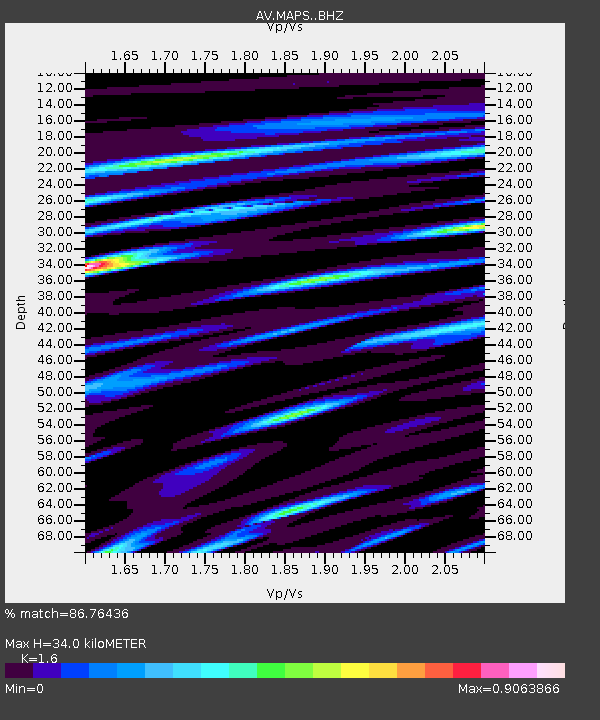
| Estimated Moho Depth: |
34.0 km |
| Estimated Crust Vp/Vs: |
1.60 |
| Assumed Crust Vp: |
3.943 km/s |
| Estimated Crust Vs: |
2.465 km/s |
| Estimated Crust Poisson's Ratio: |
0.18 |
|
| Radial Match: |
86.76436 % |
| Radial Bump: |
400 |
| Transverse Match: |
91.60525 % |
| Transverse Bump: |
196 |
| SOD ConfigId: |
24890451 |
| Insert Time: |
2021-06-02 13:50:56.703 +0000 |
| GWidth: |
2.5 |
| Max Bumps: |
400 |
| Tol: |
0.001 |
|

Signal To Noise
| Channel | StoN | STA | LTA |
| AV:MAPS: :BHZ:20210511T15:37:55.880028Z | 0.9472844 | 5.525862E-7 | 5.8333717E-7 |
| AV:MAPS: :BHN:20210511T15:37:55.880028Z | 1.0929238 | 2.0224677E-6 | 1.850511E-6 |
| AV:MAPS: :BHE:20210511T15:37:55.880028Z | 0.9574144 | 1.092998E-6 | 1.1416143E-6 |
| Arrivals |
| Ps | 5.3 SECOND |
| PpPs | 22 SECOND |
| PsPs/PpSs | 27 SECOND |


