You are here: Home > Network List > US - United States National Seismic Network Stations List
> Station EGMT Eagleton, Montana, USA > Earthquake Result Viewer
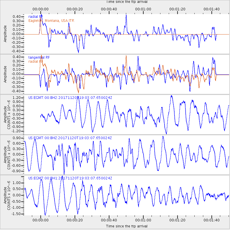
EGMT Eagleton, Montana, USA - Earthquake Result Viewer
*The percent match for this event was below the threshold and hence no stack was calculated.
| Earthquake location: |
Samoa Islands Region |
| Earthquake latitude/longitude: |
-14.4/-175.1 |
| Earthquake time(UTC): |
2017/11/20 (324) 18:51:04 GMT |
| Earthquake Depth: |
10 km |
| Earthquake Magnitude: |
6.2 Mi |
| Earthquake Catalog/Contributor: |
NEIC PDE/pt |
|
| Network: |
US United States National Seismic Network |
| Station: |
EGMT Eagleton, Montana, USA |
| Lat/Lon: |
48.02 N/109.75 W |
| Elevation: |
1055 m |
|
| Distance: |
84.9 deg |
| Az: |
37.783 deg |
| Baz: |
242.192 deg |
| Ray Param: |
$rayparam |
*The percent match for this event was below the threshold and hence was not used in the summary stack. |
|
| Radial Match: |
48.86471 % |
| Radial Bump: |
400 |
| Transverse Match: |
52.859135 % |
| Transverse Bump: |
400 |
| SOD ConfigId: |
2429771 |
| Insert Time: |
2017-12-04 18:54:57.423 +0000 |
| GWidth: |
2.5 |
| Max Bumps: |
400 |
| Tol: |
0.001 |
|
Signal To Noise
| Channel | StoN | STA | LTA |
| US:EGMT:00:BHZ:20171120T19:03:07.650024Z | 1.3335621 | 4.702077E-7 | 3.525953E-7 |
| US:EGMT:00:BH1:20171120T19:03:07.650024Z | 3.3462698 | 9.750584E-7 | 2.9138664E-7 |
| US:EGMT:00:BH2:20171120T19:03:07.650024Z | 1.6464765 | 7.614358E-7 | 4.624638E-7 |
| Arrivals |
| Ps | |
| PpPs | |
| PsPs/PpSs | |


