You are here: Home > Network List > XW97 - Tien Shan Continental Dynamics Stations List
> Station KHA XW.KHA > Earthquake Result Viewer
KHA XW.KHA - Earthquake Result Viewer
| Earthquake location: |
Minahassa Peninsula, Sulawesi |
| Earthquake latitude/longitude: |
0.2/119.5 |
| Earthquake time(UTC): |
1999/02/23 (054) 07:27:56 GMT |
| Earthquake Depth: |
33 km |
| Earthquake Magnitude: |
5.6 MB, 5.8 MS |
| Earthquake Catalog/Contributor: |
WHDF/NEIC |
|
| Network: |
XW Tien Shan Continental Dynamics |
| Station: |
KHA XW.KHA |
| Lat/Lon: |
44.21 N/74.00 E |
| Elevation: |
1014 m |
|
| Distance: |
59.6 deg |
| Az: |
323.476 deg |
| Baz: |
124.149 deg |
| Ray Param: |
0.06202615 |
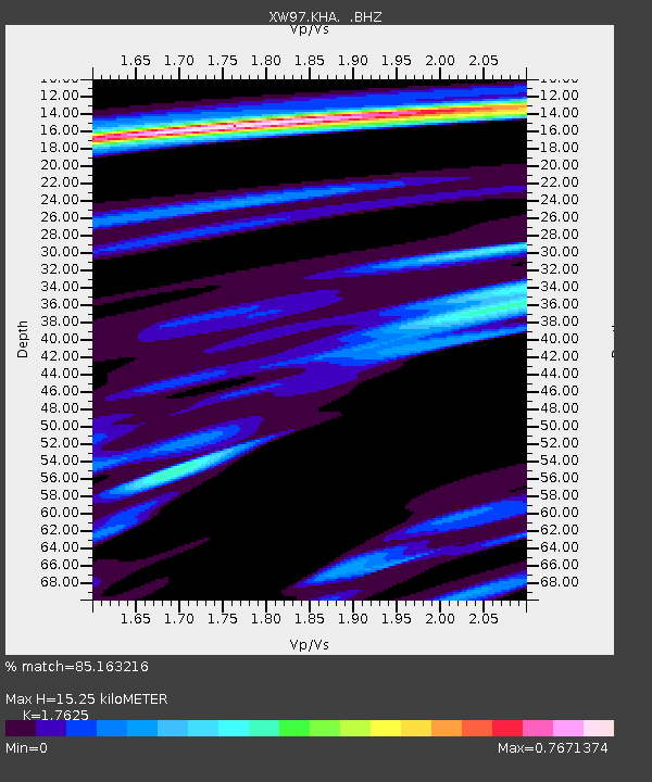
| Estimated Moho Depth: |
15.25 km |
| Estimated Crust Vp/Vs: |
1.76 |
| Assumed Crust Vp: |
6.35 km/s |
| Estimated Crust Vs: |
3.603 km/s |
| Estimated Crust Poisson's Ratio: |
0.26 |
|
| Radial Match: |
85.163216 % |
| Radial Bump: |
325 |
| Transverse Match: |
80.156334 % |
| Transverse Bump: |
400 |
| SOD ConfigId: |
4480 |
| Insert Time: |
2010-02-26 15:34:45.010 +0000 |
| GWidth: |
2.5 |
| Max Bumps: |
400 |
| Tol: |
0.001 |
|
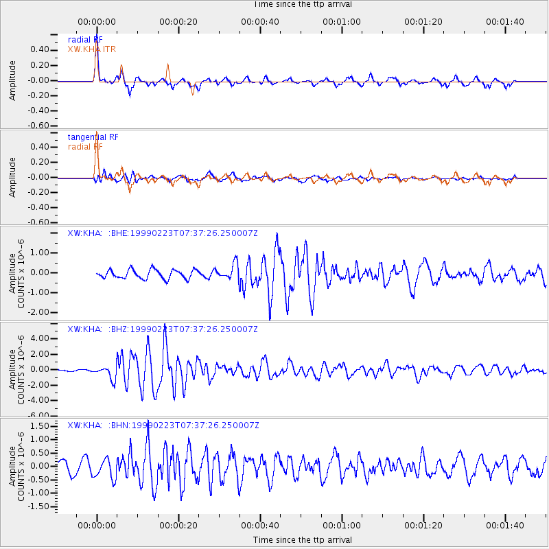
Signal To Noise
| Channel | StoN | STA | LTA |
| XW:KHA: :BHZ:19990223T07:37:26.250007Z | 10.618973 | 8.5853713E-7 | 8.084936E-8 |
| XW:KHA: :BHN:19990223T07:37:26.250007Z | 1.9164941 | 3.6431115E-7 | 1.9009248E-7 |
| XW:KHA: :BHE:19990223T07:37:26.250007Z | 1.7859709 | 3.943275E-7 | 2.2079165E-7 |
| Arrivals |
| Ps | 1.9 SECOND |
| PpPs | 6.3 SECOND |
| PsPs/PpSs | 8.3 SECOND |


