You are here: Home > Network List > II - Global Seismograph Network (GSN - IRIS/IDA) Stations List
> Station WRAB Tennant Creek, NT, Australia > Earthquake Result Viewer
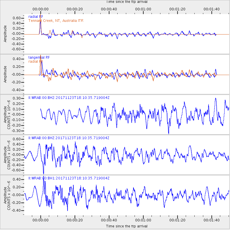
WRAB Tennant Creek, NT, Australia - Earthquake Result Viewer
*The percent match for this event was below the threshold and hence no stack was calculated.
| Earthquake location: |
Ryukyu Islands, Japan |
| Earthquake latitude/longitude: |
27.1/130.4 |
| Earthquake time(UTC): |
2017/11/23 (327) 18:02:35 GMT |
| Earthquake Depth: |
10 km |
| Earthquake Magnitude: |
5.5 Mww |
| Earthquake Catalog/Contributor: |
NEIC PDE/us |
|
| Network: |
II Global Seismograph Network (GSN - IRIS/IDA) |
| Station: |
WRAB Tennant Creek, NT, Australia |
| Lat/Lon: |
19.93 S/134.36 E |
| Elevation: |
366 m |
|
| Distance: |
47.0 deg |
| Az: |
174.867 deg |
| Baz: |
355.139 deg |
| Ray Param: |
$rayparam |
*The percent match for this event was below the threshold and hence was not used in the summary stack. |
|
| Radial Match: |
71.93206 % |
| Radial Bump: |
400 |
| Transverse Match: |
63.60315 % |
| Transverse Bump: |
400 |
| SOD ConfigId: |
2429771 |
| Insert Time: |
2017-12-07 18:03:35.228 +0000 |
| GWidth: |
2.5 |
| Max Bumps: |
400 |
| Tol: |
0.001 |
|
Signal To Noise
| Channel | StoN | STA | LTA |
| II:WRAB:00:BHZ:20171123T18:10:35.719004Z | 2.6571057 | 3.2287548E-7 | 1.2151398E-7 |
| II:WRAB:00:BH1:20171123T18:10:35.719004Z | 4.7077513 | 2.2104727E-7 | 4.6953897E-8 |
| II:WRAB:00:BH2:20171123T18:10:35.719004Z | 1.4005466 | 1.0254639E-7 | 7.3218835E-8 |
| Arrivals |
| Ps | |
| PpPs | |
| PsPs/PpSs | |


