You are here: Home > Network List > XW97 - Tien Shan Continental Dynamics Stations List
> Station KHA XW.KHA > Earthquake Result Viewer
KHA XW.KHA - Earthquake Result Viewer
| Earthquake location: |
Off East Coast Of Kamchatka |
| Earthquake latitude/longitude: |
52.1/159.5 |
| Earthquake time(UTC): |
1999/03/08 (067) 12:25:48 GMT |
| Earthquake Depth: |
57 km |
| Earthquake Magnitude: |
5.7 MB, 6.9 MW, 6.8 MW |
| Earthquake Catalog/Contributor: |
WHDF/NEIC |
|
| Network: |
XW Tien Shan Continental Dynamics |
| Station: |
KHA XW.KHA |
| Lat/Lon: |
44.21 N/74.00 E |
| Elevation: |
1014 m |
|
| Distance: |
54.5 deg |
| Az: |
298.228 deg |
| Baz: |
49.155 deg |
| Ray Param: |
0.06529381 |
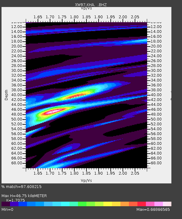
| Estimated Moho Depth: |
46.75 km |
| Estimated Crust Vp/Vs: |
1.71 |
| Assumed Crust Vp: |
6.35 km/s |
| Estimated Crust Vs: |
3.719 km/s |
| Estimated Crust Poisson's Ratio: |
0.24 |
|
| Radial Match: |
97.608215 % |
| Radial Bump: |
165 |
| Transverse Match: |
91.94373 % |
| Transverse Bump: |
400 |
| SOD ConfigId: |
4480 |
| Insert Time: |
2010-02-26 15:34:50.188 +0000 |
| GWidth: |
2.5 |
| Max Bumps: |
400 |
| Tol: |
0.001 |
|

Signal To Noise
| Channel | StoN | STA | LTA |
| XW:KHA: :BHZ:19990308T12:34:40.109995Z | 55.006287 | 3.4877287E-6 | 6.3406E-8 |
| XW:KHA: :BHN:19990308T12:34:40.109995Z | 39.16533 | 1.5105475E-6 | 3.8568487E-8 |
| XW:KHA: :BHE:19990308T12:34:40.109995Z | 29.147013 | 1.2472428E-6 | 4.2791445E-8 |
| Arrivals |
| Ps | 5.5 SECOND |
| PpPs | 19 SECOND |
| PsPs/PpSs | 24 SECOND |


