You are here: Home > Network List > CI - Caltech Regional Seismic Network Stations List
> Station BFS Mt Baldy Forest Station > Earthquake Result Viewer
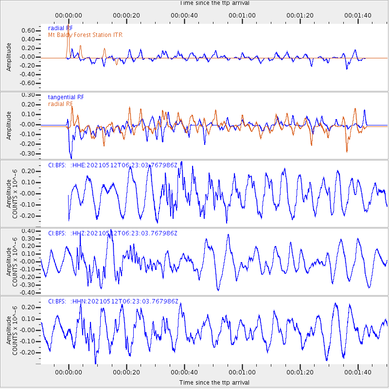
BFS Mt Baldy Forest Station - Earthquake Result Viewer
*The percent match for this event was below the threshold and hence no stack was calculated.
| Earthquake location: |
Near Coast Of Guatemala |
| Earthquake latitude/longitude: |
13.3/-90.3 |
| Earthquake time(UTC): |
2021/05/12 (132) 06:17:09 GMT |
| Earthquake Depth: |
51 km |
| Earthquake Magnitude: |
5.6 Mww |
| Earthquake Catalog/Contributor: |
NEIC PDE/us |
|
| Network: |
CI Caltech Regional Seismic Network |
| Station: |
BFS Mt Baldy Forest Station |
| Lat/Lon: |
34.24 N/117.66 W |
| Elevation: |
1312 m |
|
| Distance: |
32.3 deg |
| Az: |
314.718 deg |
| Baz: |
123.395 deg |
| Ray Param: |
$rayparam |
*The percent match for this event was below the threshold and hence was not used in the summary stack. |
|
| Radial Match: |
47.02157 % |
| Radial Bump: |
400 |
| Transverse Match: |
51.45338 % |
| Transverse Bump: |
400 |
| SOD ConfigId: |
24890451 |
| Insert Time: |
2021-06-02 14:17:51.457 +0000 |
| GWidth: |
2.5 |
| Max Bumps: |
400 |
| Tol: |
0.001 |
|
Signal To Noise
| Channel | StoN | STA | LTA |
| CI:BFS: :HHZ:20210512T06:23:03.767986Z | 1.1351557 | 1.4604187E-7 | 1.2865361E-7 |
| CI:BFS: :HHN:20210512T06:23:03.767986Z | 1.010015 | 9.968737E-8 | 9.869889E-8 |
| CI:BFS: :HHE:20210512T06:23:03.767986Z | 1.0426903 | 1.2329689E-7 | 1.1824882E-7 |
| Arrivals |
| Ps | |
| PpPs | |
| PsPs/PpSs | |


