You are here: Home > Network List > XR01 - Florida to Edmonton Seismic Experiment Stations List
> Station FA10 fled station 10 > Earthquake Result Viewer
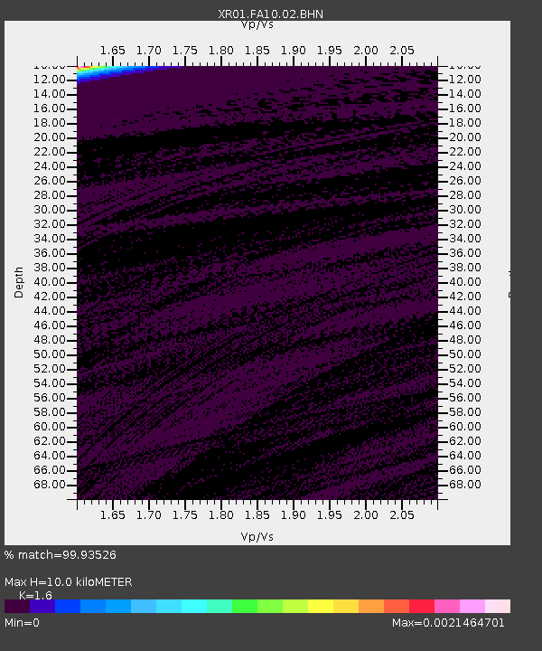
FA10 fled station 10 - Earthquake Result Viewer
| Earthquake location: |
Kuril Islands |
| Earthquake latitude/longitude: |
48.5/153.3 |
| Earthquake time(UTC): |
2002/07/17 (198) 02:20:33 GMT |
| Earthquake Depth: |
148 km |
| Earthquake Magnitude: |
5.3 MB, 5.6 MW, 5.6 MW |
| Earthquake Catalog/Contributor: |
WHDF/NEIC |
|
| Network: |
XR Florida to Edmonton Seismic Experiment |
| Station: |
FA10 fled station 10 |
| Lat/Lon: |
40.10 N/92.67 W |
| Elevation: |
2187 m |
|
| Distance: |
74.3 deg |
| Az: |
46.686 deg |
| Baz: |
320.896 deg |
| Ray Param: |
0.052076396 |
| Estimated Moho Depth: |
10.0 km |
| Estimated Crust Vp/Vs: |
1.60 |
| Assumed Crust Vp: |
6.498 km/s |
| Estimated Crust Vs: |
4.061 km/s |
| Estimated Crust Poisson's Ratio: |
0.18 |
|
| Radial Match: |
99.93526 % |
| Radial Bump: |
15 |
| Transverse Match: |
99.410164 % |
| Transverse Bump: |
304 |
| SOD ConfigId: |
248956 |
| Insert Time: |
2010-03-09 08:10:32.479 +0000 |
| GWidth: |
2.5 |
| Max Bumps: |
400 |
| Tol: |
0.001 |
|

Signal To Noise
| Channel | StoN | STA | LTA |
| XR:FA10:02:BHN:20020717T02:31:23.777021Z | 1.743322 | 167.05394 | 95.825066 |
| XR:FA10:02:BHE:20020717T02:31:23.777021Z | 1.0824184 | 252.48827 | 233.26308 |
| XR:FA10:02:BHZ:20020717T02:31:23.777021Z | 1.8887675 | 441.0318 | 233.50244 |
| Arrivals |
| Ps | 1.0 SECOND |
| PpPs | 3.9 SECOND |
| PsPs/PpSs | 4.8 SECOND |


