You are here: Home > Network List > NE - New England Seismic Network Stations List
> Station HNH Hanover, NH, USA > Earthquake Result Viewer
HNH Hanover, NH, USA - Earthquake Result Viewer
| Earthquake location: |
Near Coast Of Guatemala |
| Earthquake latitude/longitude: |
13.3/-90.2 |
| Earthquake time(UTC): |
2021/05/12 (132) 08:45:48 GMT |
| Earthquake Depth: |
46 km |
| Earthquake Magnitude: |
5.9 mww |
| Earthquake Catalog/Contributor: |
NEIC PDE/us |
|
| Network: |
NE New England Seismic Network |
| Station: |
HNH Hanover, NH, USA |
| Lat/Lon: |
43.71 N/72.29 W |
| Elevation: |
180 m |
|
| Distance: |
34.0 deg |
| Az: |
23.549 deg |
| Baz: |
212.429 deg |
| Ray Param: |
0.07787894 |
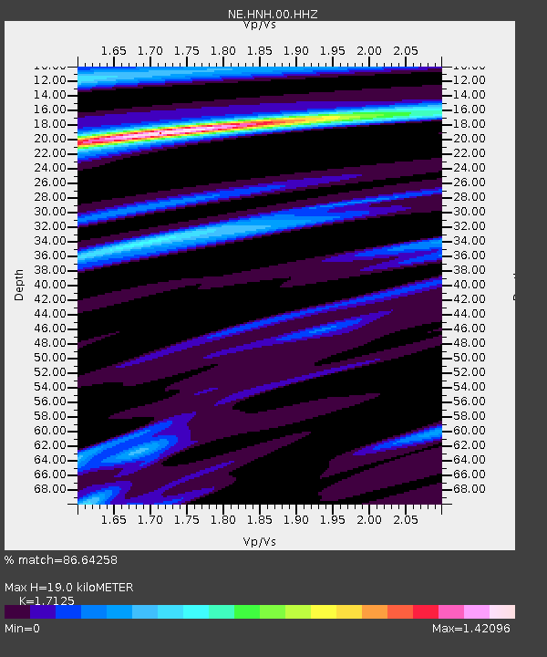
| Estimated Moho Depth: |
19.0 km |
| Estimated Crust Vp/Vs: |
1.71 |
| Assumed Crust Vp: |
6.419 km/s |
| Estimated Crust Vs: |
3.748 km/s |
| Estimated Crust Poisson's Ratio: |
0.24 |
|
| Radial Match: |
86.64258 % |
| Radial Bump: |
311 |
| Transverse Match: |
60.45652 % |
| Transverse Bump: |
393 |
| SOD ConfigId: |
24890451 |
| Insert Time: |
2021-06-02 14:41:43.734 +0000 |
| GWidth: |
2.5 |
| Max Bumps: |
400 |
| Tol: |
0.001 |
|

Signal To Noise
| Channel | StoN | STA | LTA |
| NE:HNH:00:HHZ:20210512T08:51:56.979001Z | 1.0133187 | 2.8327867E-7 | 2.7955537E-7 |
| NE:HNH:00:HH1:20210512T08:51:56.979001Z | 2.7155232 | 4.2492698E-7 | 1.564807E-7 |
| NE:HNH:00:HH2:20210512T08:51:56.979001Z | 1.6392913 | 2.5781964E-7 | 1.5727507E-7 |
| Arrivals |
| Ps | 2.3 SECOND |
| PpPs | 7.4 SECOND |
| PsPs/PpSs | 9.7 SECOND |


