You are here: Home > Network List > XW97 - Tien Shan Continental Dynamics Stations List
> Station KHA XW.KHA > Earthquake Result Viewer
KHA XW.KHA - Earthquake Result Viewer
| Earthquake location: |
Talaud Islands, Indonesia |
| Earthquake latitude/longitude: |
4.1/125.6 |
| Earthquake time(UTC): |
2000/04/03 (094) 15:20:01 GMT |
| Earthquake Depth: |
150 km |
| Earthquake Magnitude: |
5.9 MB, 6.2 MW, 6.0 MW |
| Earthquake Catalog/Contributor: |
WHDF/NEIC |
|
| Network: |
XW Tien Shan Continental Dynamics |
| Station: |
KHA XW.KHA |
| Lat/Lon: |
44.21 N/74.00 E |
| Elevation: |
1014 m |
|
| Distance: |
60.4 deg |
| Az: |
319.566 deg |
| Baz: |
115.894 deg |
| Ray Param: |
0.061123658 |
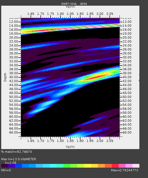
| Estimated Moho Depth: |
13.5 km |
| Estimated Crust Vp/Vs: |
2.09 |
| Assumed Crust Vp: |
6.35 km/s |
| Estimated Crust Vs: |
3.038 km/s |
| Estimated Crust Poisson's Ratio: |
0.35 |
|
| Radial Match: |
92.76674 % |
| Radial Bump: |
400 |
| Transverse Match: |
86.415245 % |
| Transverse Bump: |
400 |
| SOD ConfigId: |
20082 |
| Insert Time: |
2010-02-26 15:35:01.374 +0000 |
| GWidth: |
2.5 |
| Max Bumps: |
400 |
| Tol: |
0.001 |
|

Signal To Noise
| Channel | StoN | STA | LTA |
| XW:KHA: :BHN:20000403T15:29:24.448018Z | 7.7207336 | 3.8194773E-7 | 4.947039E-8 |
| XW:KHA: :BHE:20000403T15:29:24.448018Z | 15.56961 | 7.6972947E-7 | 4.9437944E-8 |
| XW:KHA: :BHZ:20000403T15:29:24.448018Z | 23.393623 | 1.9345207E-6 | 8.269436E-8 |
| Arrivals |
| Ps | 2.4 SECOND |
| PpPs | 6.3 SECOND |
| PsPs/PpSs | 8.7 SECOND |


