You are here: Home > Network List > XW97 - Tien Shan Continental Dynamics Stations List
> Station KHA XW.KHA > Earthquake Result Viewer
KHA XW.KHA - Earthquake Result Viewer
| Earthquake location: |
Minahassa Peninsula, Sulawesi |
| Earthquake latitude/longitude: |
0.3/122.1 |
| Earthquake time(UTC): |
2000/04/03 (094) 08:55:00 GMT |
| Earthquake Depth: |
187 km |
| Earthquake Magnitude: |
5.6 MB, 5.5 MW, 5.4 MW |
| Earthquake Catalog/Contributor: |
WHDF/NEIC |
|
| Network: |
XW Tien Shan Continental Dynamics |
| Station: |
KHA XW.KHA |
| Lat/Lon: |
44.21 N/74.00 E |
| Elevation: |
1014 m |
|
| Distance: |
61.1 deg |
| Az: |
322.323 deg |
| Baz: |
121.799 deg |
| Ray Param: |
0.060548093 |
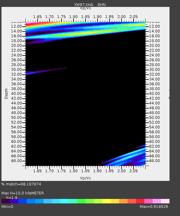
| Estimated Moho Depth: |
10.0 km |
| Estimated Crust Vp/Vs: |
1.60 |
| Assumed Crust Vp: |
6.35 km/s |
| Estimated Crust Vs: |
3.969 km/s |
| Estimated Crust Poisson's Ratio: |
0.18 |
|
| Radial Match: |
86.187874 % |
| Radial Bump: |
400 |
| Transverse Match: |
84.14237 % |
| Transverse Bump: |
400 |
| SOD ConfigId: |
20082 |
| Insert Time: |
2010-02-26 15:35:03.550 +0000 |
| GWidth: |
2.5 |
| Max Bumps: |
400 |
| Tol: |
0.001 |
|
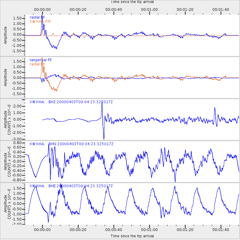
Signal To Noise
| Channel | StoN | STA | LTA |
| XW:KHA: :BHN:20000403T09:04:23.325017Z | 0.92215055 | 2.8168787E-7 | 3.0546843E-7 |
| XW:KHA: :BHE:20000403T09:04:23.325017Z | 0.7030567 | 6.274176E-7 | 8.9241394E-7 |
| XW:KHA: :BHZ:20000403T09:04:23.325017Z | 7.5602436 | 1.0810433E-6 | 1.4299053E-7 |
| Arrivals |
| Ps | 1.0 SECOND |
| PpPs | 3.9 SECOND |
| PsPs/PpSs | 4.9 SECOND |


