You are here: Home > Network List > US - United States National Seismic Network Stations List
> Station MSO Missoula, Montana, USA > Earthquake Result Viewer
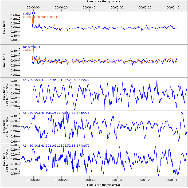
MSO Missoula, Montana, USA - Earthquake Result Viewer
*The percent match for this event was below the threshold and hence no stack was calculated.
| Earthquake location: |
Near Coast Of Guatemala |
| Earthquake latitude/longitude: |
13.3/-90.2 |
| Earthquake time(UTC): |
2021/05/12 (132) 08:45:48 GMT |
| Earthquake Depth: |
46 km |
| Earthquake Magnitude: |
5.9 mww |
| Earthquake Catalog/Contributor: |
NEIC PDE/us |
|
| Network: |
US United States National Seismic Network |
| Station: |
MSO Missoula, Montana, USA |
| Lat/Lon: |
46.83 N/113.94 W |
| Elevation: |
1264 m |
|
| Distance: |
38.9 deg |
| Az: |
333.885 deg |
| Baz: |
141.39 deg |
| Ray Param: |
$rayparam |
*The percent match for this event was below the threshold and hence was not used in the summary stack. |
|
| Radial Match: |
74.253845 % |
| Radial Bump: |
343 |
| Transverse Match: |
53.784897 % |
| Transverse Bump: |
400 |
| SOD ConfigId: |
24890451 |
| Insert Time: |
2021-06-02 14:45:48.892 +0000 |
| GWidth: |
2.5 |
| Max Bumps: |
400 |
| Tol: |
0.001 |
|
Signal To Noise
| Channel | StoN | STA | LTA |
| US:MSO:00:BHZ:20210512T08:52:38.874997Z | 1.8630865 | 2.3143194E-7 | 1.2421964E-7 |
| US:MSO:00:BH1:20210512T08:52:38.874997Z | 1.1785358 | 1.216595E-7 | 1.0322936E-7 |
| US:MSO:00:BH2:20210512T08:52:38.874997Z | 1.4859464 | 1.9800748E-7 | 1.3325345E-7 |
| Arrivals |
| Ps | |
| PpPs | |
| PsPs/PpSs | |


