You are here: Home > Network List > UW - Pacific Northwest Regional Seismic Network Stations List
> Station HOOD Mt Hood Meadows, OR CREST BB SMO > Earthquake Result Viewer
HOOD Mt Hood Meadows, OR CREST BB SMO - Earthquake Result Viewer
| Earthquake location: |
Near Coast Of Guatemala |
| Earthquake latitude/longitude: |
13.3/-90.2 |
| Earthquake time(UTC): |
2021/05/12 (132) 08:45:48 GMT |
| Earthquake Depth: |
46 km |
| Earthquake Magnitude: |
5.9 mww |
| Earthquake Catalog/Contributor: |
NEIC PDE/us |
|
| Network: |
UW Pacific Northwest Regional Seismic Network |
| Station: |
HOOD Mt Hood Meadows, OR CREST BB SMO |
| Lat/Lon: |
45.32 N/121.65 W |
| Elevation: |
1520 m |
|
| Distance: |
41.6 deg |
| Az: |
326.304 deg |
| Baz: |
130.054 deg |
| Ray Param: |
0.07359796 |
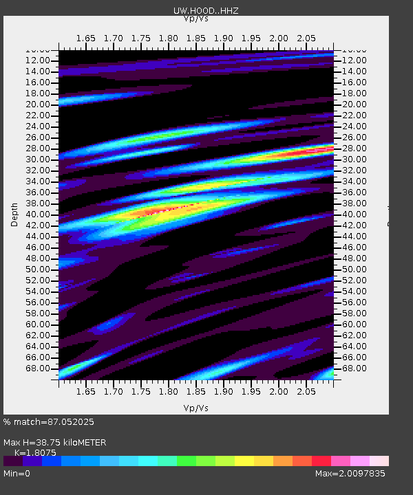
| Estimated Moho Depth: |
38.75 km |
| Estimated Crust Vp/Vs: |
1.81 |
| Assumed Crust Vp: |
6.597 km/s |
| Estimated Crust Vs: |
3.65 km/s |
| Estimated Crust Poisson's Ratio: |
0.28 |
|
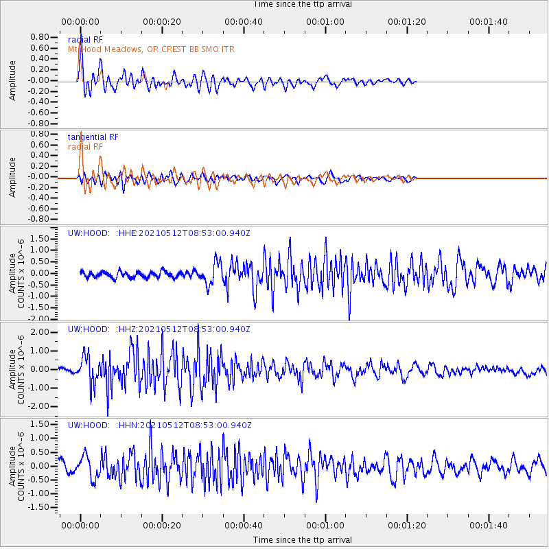
| Radial Match: |
87.052025 % |
| Radial Bump: |
400 |
| Transverse Match: |
73.49419 % |
| Transverse Bump: |
400 |
| SOD ConfigId: |
24890451 |
| Insert Time: |
2021-06-02 14:47:03.896 +0000 |
| GWidth: |
2.5 |
| Max Bumps: |
400 |
| Tol: |
0.001 |
|
Signal To Noise
| Channel | StoN | STA | LTA |
| UW:HOOD: :HHZ:20210512T08:53:00.940Z | 7.244004 | 7.484359E-7 | 1.03317994E-7 |
| UW:HOOD: :HHN:20210512T08:53:00.940Z | 2.81205 | 4.131924E-7 | 1.4693636E-7 |
| UW:HOOD: :HHE:20210512T08:53:00.940Z | 3.776724 | 4.942341E-7 | 1.3086317E-7 |
| Arrivals |
| Ps | 5.1 SECOND |
| PpPs | 15 SECOND |
| PsPs/PpSs | 20 SECOND |


