You are here: Home > Network List > XW97 - Tien Shan Continental Dynamics Stations List
> Station KHA XW.KHA > Earthquake Result Viewer
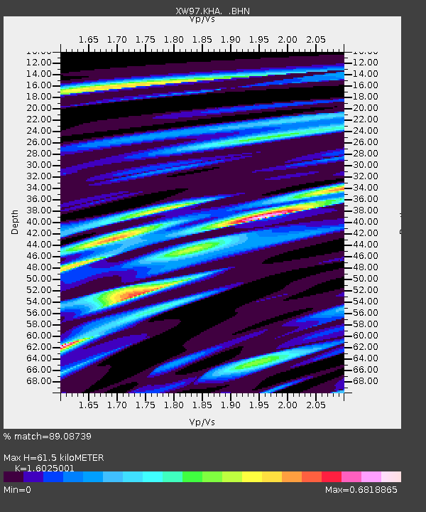
KHA XW.KHA - Earthquake Result Viewer
| Earthquake location: |
Northeast Of Taiwan |
| Earthquake latitude/longitude: |
26.1/124.5 |
| Earthquake time(UTC): |
2000/01/28 (028) 16:39:24 GMT |
| Earthquake Depth: |
194 km |
| Earthquake Magnitude: |
6.1 MB, 6.0 MW, 6.0 MW |
| Earthquake Catalog/Contributor: |
WHDF/NEIC |
|
| Network: |
XW Tien Shan Continental Dynamics |
| Station: |
KHA XW.KHA |
| Lat/Lon: |
44.21 N/74.00 E |
| Elevation: |
1014 m |
|
| Distance: |
44.3 deg |
| Az: |
307.445 deg |
| Baz: |
96.83 deg |
| Ray Param: |
0.07123112 |
| Estimated Moho Depth: |
61.5 km |
| Estimated Crust Vp/Vs: |
1.60 |
| Assumed Crust Vp: |
6.35 km/s |
| Estimated Crust Vs: |
3.963 km/s |
| Estimated Crust Poisson's Ratio: |
0.18 |
|
| Radial Match: |
89.08739 % |
| Radial Bump: |
375 |
| Transverse Match: |
72.87315 % |
| Transverse Bump: |
400 |
| SOD ConfigId: |
20082 |
| Insert Time: |
2010-02-26 15:35:10.944 +0000 |
| GWidth: |
2.5 |
| Max Bumps: |
400 |
| Tol: |
0.001 |
|

Signal To Noise
| Channel | StoN | STA | LTA |
| XW:KHA: :BHN:20000128T16:46:44.549012Z | 2.5660565 | 4.5530138E-7 | 1.7743234E-7 |
| XW:KHA: :BHE:20000128T16:46:44.549012Z | 12.260045 | 1.6509734E-6 | 1.3466291E-7 |
| XW:KHA: :BHZ:20000128T16:46:44.549012Z | 18.503052 | 3.0965064E-6 | 1.673511E-7 |
| Arrivals |
| Ps | 6.3 SECOND |
| PpPs | 24 SECOND |
| PsPs/PpSs | 30 SECOND |


