You are here: Home > Network List > CI - Caltech Regional Seismic Network Stations List
> Station SMM Simmler, CA, USA > Earthquake Result Viewer
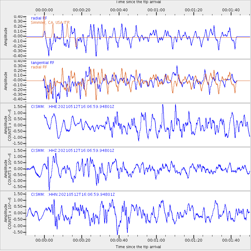
SMM Simmler, CA, USA - Earthquake Result Viewer
*The percent match for this event was below the threshold and hence no stack was calculated.
| Earthquake location: |
Near Coast Of Peru |
| Earthquake latitude/longitude: |
-14.2/-75.7 |
| Earthquake time(UTC): |
2021/05/12 (132) 15:56:56 GMT |
| Earthquake Depth: |
34 km |
| Earthquake Magnitude: |
5.5 mww |
| Earthquake Catalog/Contributor: |
NEIC PDE/us |
|
| Network: |
CI Caltech Regional Seismic Network |
| Station: |
SMM Simmler, CA, USA |
| Lat/Lon: |
35.31 N/120.00 W |
| Elevation: |
599 m |
|
| Distance: |
64.7 deg |
| Az: |
320.795 deg |
| Baz: |
131.432 deg |
| Ray Param: |
$rayparam |
*The percent match for this event was below the threshold and hence was not used in the summary stack. |
|
| Radial Match: |
66.00163 % |
| Radial Bump: |
400 |
| Transverse Match: |
56.14014 % |
| Transverse Bump: |
400 |
| SOD ConfigId: |
24890451 |
| Insert Time: |
2021-06-02 14:58:17.044 +0000 |
| GWidth: |
2.5 |
| Max Bumps: |
400 |
| Tol: |
0.001 |
|
Signal To Noise
| Channel | StoN | STA | LTA |
| CI:SMM: :HHZ:20210512T16:06:59.94801Z | 2.5438786 | 6.867848E-7 | 2.699755E-7 |
| CI:SMM: :HHN:20210512T16:06:59.94801Z | 0.9903841 | 3.525305E-7 | 3.559533E-7 |
| CI:SMM: :HHE:20210512T16:06:59.94801Z | 0.56375897 | 2.5955487E-7 | 4.6040043E-7 |
| Arrivals |
| Ps | |
| PpPs | |
| PsPs/PpSs | |


