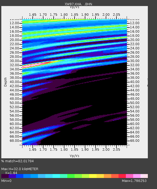
KHA XW.KHA - Earthquake Result Viewer
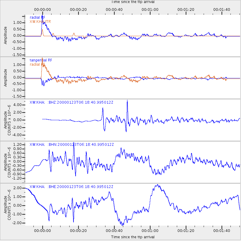
Earthquake location: Flores Sea
Earthquake latitude/longitude: -8.0/120.6
Earthquake time(UTC): 2000/01/23 (023) 06:08:24 GMT
Earthquake Depth: 47 km
Earthquake Magnitude: 5.7 MB, 5.2 MS, 5.8 MW, 5.7 MW
Earthquake Catalog/Contributor: WHDF/NEIC
Network: XW Tien Shan Continental Dynamics
Station: KHA XW.KHA
Lat/Lon: 44.21 N/74.00 E
Elevation: 1014 m
Distance: 66.8 deg
Az: 325.351 deg
Baz: 128.46 deg
Ray Param: 0.05726648
Estimated Moho Depth: 32.0 km
Estimated Crust Vp/Vs: 1.64
Assumed Crust Vp: 6.35 km/s
Estimated Crust Vs: 3.872 km/s
Estimated Crust Poisson's Ratio: 0.20
Radial Match: 82.01784 %
Radial Bump: 400
Transverse Match: 81.63349 %
Transverse Bump: 400
SOD ConfigId: 20082
Insert Time: 2010-02-26 15:35:13.098 +0000
GWidth: 2.5
Max Bumps: 400
Tol: 0.001

Signal To Noise

ChannelStoNSTALTA
XW:KHA: :BHN:20000123T06:18:40.995012Z0.63394833.134067E-74.9437267E-7
XW:KHA: :BHE:20000123T06:18:40.995012Z0.370765.275995E-71.4230218E-6
XW:KHA: :BHZ:20000123T06:18:40.995012Z5.92057041.2918358E-62.1819447E-7
Arrivals
Ps3.4 SECOND
PpPs13 SECOND
PsPs/PpSs16 SECOND