You are here: Home > Network List > AK - Alaska Regional Network Stations List
> Station M20K Styx River, AK, USA > Earthquake Result Viewer
M20K Styx River, AK, USA - Earthquake Result Viewer
| Earthquake location: |
North Of Halmahera, Indonesia |
| Earthquake latitude/longitude: |
3.9/128.6 |
| Earthquake time(UTC): |
2021/05/12 (132) 18:20:29 GMT |
| Earthquake Depth: |
60 km |
| Earthquake Magnitude: |
5.5 mww |
| Earthquake Catalog/Contributor: |
NEIC PDE/us |
|
| Network: |
AK Alaska Regional Network |
| Station: |
M20K Styx River, AK, USA |
| Lat/Lon: |
61.88 N/153.13 W |
| Elevation: |
1107 m |
|
| Distance: |
81.0 deg |
| Az: |
28.008 deg |
| Baz: |
261.459 deg |
| Ray Param: |
0.04778895 |
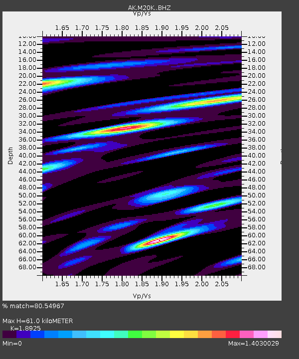
| Estimated Moho Depth: |
61.0 km |
| Estimated Crust Vp/Vs: |
1.89 |
| Assumed Crust Vp: |
6.566 km/s |
| Estimated Crust Vs: |
3.47 km/s |
| Estimated Crust Poisson's Ratio: |
0.31 |
|
| Radial Match: |
80.54967 % |
| Radial Bump: |
400 |
| Transverse Match: |
65.44373 % |
| Transverse Bump: |
400 |
| SOD ConfigId: |
24890451 |
| Insert Time: |
2021-06-02 15:14:16.196 +0000 |
| GWidth: |
2.5 |
| Max Bumps: |
400 |
| Tol: |
0.001 |
|

Signal To Noise
| Channel | StoN | STA | LTA |
| AK:M20K: :BHZ:20210512T18:32:06.299991Z | 8.4122095 | 5.457069E-7 | 6.487082E-8 |
| AK:M20K: :BHN:20210512T18:32:06.299991Z | 2.7698722 | 1.4729333E-7 | 5.3176944E-8 |
| AK:M20K: :BHE:20210512T18:32:06.299991Z | 3.1645155 | 2.0586958E-7 | 6.5055644E-8 |
| Arrivals |
| Ps | 8.5 SECOND |
| PpPs | 26 SECOND |
| PsPs/PpSs | 35 SECOND |


