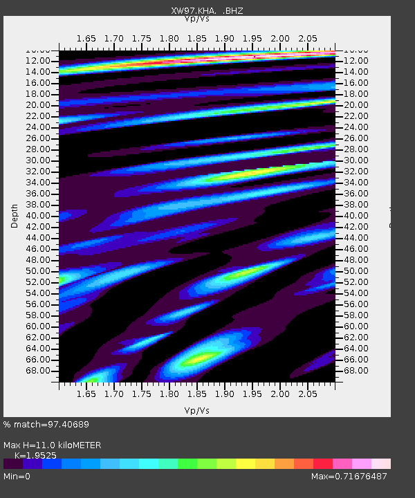
KHA XW.KHA - Earthquake Result Viewer

Earthquake location: Kodiak Island Region, Alaska
Earthquake latitude/longitude: 56.4/-152.9
Earthquake time(UTC): 1999/05/07 (127) 14:13:52 GMT
Earthquake Depth: 20 km
Earthquake Magnitude: 5.7 MB, 6.1 MS, 6.4 MW, 5.7 ME
Earthquake Catalog/Contributor: WHDF/NEIC
Network: XW Tien Shan Continental Dynamics
Station: KHA XW.KHA
Lat/Lon: 44.21 N/74.00 E
Elevation: 1014 m
Distance: 72.3 deg
Az: 326.52 deg
Baz: 25.233 deg
Ray Param: 0.05376242
Estimated Moho Depth: 11.0 km
Estimated Crust Vp/Vs: 1.95
Assumed Crust Vp: 6.35 km/s
Estimated Crust Vs: 3.252 km/s
Estimated Crust Poisson's Ratio: 0.32
Radial Match: 97.40689 %
Radial Bump: 400
Transverse Match: 88.92989 %
Transverse Bump: 400
SOD ConfigId: 4480
Insert Time: 2010-02-26 15:35:15.508 +0000
GWidth: 2.5
Max Bumps: 400
Tol: 0.001

Signal To Noise

ChannelStoNSTALTA
XW:KHA: :BHZ:19990507T14:24:44.938003Z12.9474029.793777E-77.5642795E-8
XW:KHA: :BHN:19990507T14:24:44.938003Z11.5492894.2212778E-73.6550112E-8
XW:KHA: :BHE:19990507T14:24:44.938003Z4.62436061.4277359E-73.0874233E-8
Arrivals
Ps1.7 SECOND
PpPs5.0 SECOND
PsPs/PpSs6.7 SECOND