You are here: Home > Network List > GS - US Geological Survey Networks Stations List
> Station KAN09 Caldwell North Station > Earthquake Result Viewer
KAN09 Caldwell North Station - Earthquake Result Viewer
| Earthquake location: |
Near Coast Of Peru |
| Earthquake latitude/longitude: |
-14.5/-76.3 |
| Earthquake time(UTC): |
2017/11/29 (333) 06:29:05 GMT |
| Earthquake Depth: |
10 km |
| Earthquake Magnitude: |
5.7 Mww |
| Earthquake Catalog/Contributor: |
NEIC PDE/us |
|
| Network: |
GS US Geological Survey Networks |
| Station: |
KAN09 Caldwell North Station |
| Lat/Lon: |
37.14 N/97.62 W |
| Elevation: |
371 m |
|
| Distance: |
55.1 deg |
| Az: |
339.272 deg |
| Baz: |
154.595 deg |
| Ray Param: |
0.06500561 |
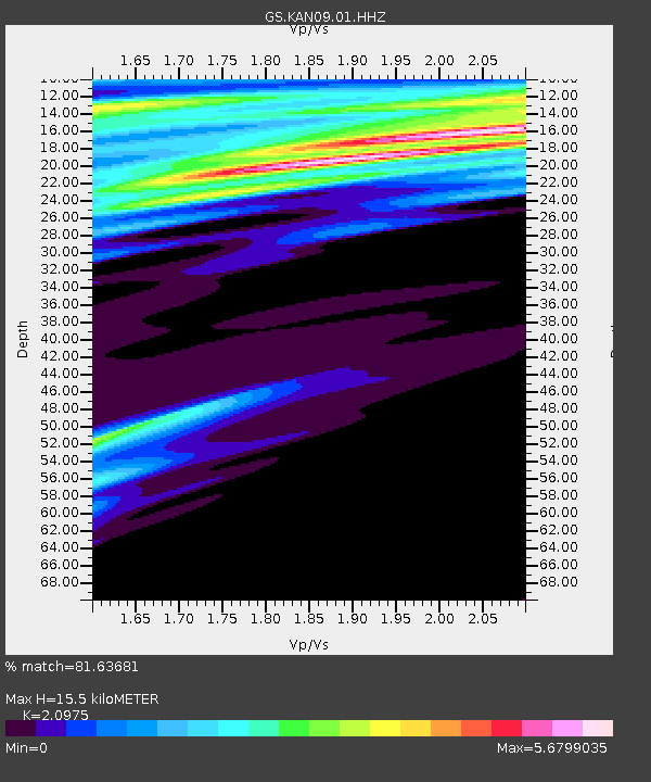
| Estimated Moho Depth: |
15.5 km |
| Estimated Crust Vp/Vs: |
2.10 |
| Assumed Crust Vp: |
6.483 km/s |
| Estimated Crust Vs: |
3.091 km/s |
| Estimated Crust Poisson's Ratio: |
0.35 |
|
| Radial Match: |
81.63681 % |
| Radial Bump: |
302 |
| Transverse Match: |
78.27473 % |
| Transverse Bump: |
400 |
| SOD ConfigId: |
2429771 |
| Insert Time: |
2017-12-13 06:30:29.663 +0000 |
| GWidth: |
2.5 |
| Max Bumps: |
400 |
| Tol: |
0.001 |
|

Signal To Noise
| Channel | StoN | STA | LTA |
| GS:KAN09:01:HHZ:20171129T06:38:06.783979Z | 1.0087004 | 3.209057E-7 | 3.1813778E-7 |
| GS:KAN09:01:HHN:20171129T06:38:06.783979Z | 1.2174494 | 1.1566647E-6 | 9.500721E-7 |
| GS:KAN09:01:HHE:20171129T06:38:06.783979Z | 0.21330804 | 1.2823397E-6 | 6.01168E-6 |
| Arrivals |
| Ps | 2.7 SECOND |
| PpPs | 7.1 SECOND |
| PsPs/PpSs | 9.8 SECOND |


