You are here: Home > Network List > AE - Arizona Broadband Seismic Network Stations List
> Station X16A Lo Mia Camp, Pine, AZ, USA > Earthquake Result Viewer
X16A Lo Mia Camp, Pine, AZ, USA - Earthquake Result Viewer
| Earthquake location: |
South Of Panama |
| Earthquake latitude/longitude: |
6.8/-82.4 |
| Earthquake time(UTC): |
2021/05/13 (133) 09:42:12 GMT |
| Earthquake Depth: |
10 km |
| Earthquake Magnitude: |
6.0 mww |
| Earthquake Catalog/Contributor: |
NEIC PDE/us |
|
| Network: |
AE Arizona Broadband Seismic Network |
| Station: |
X16A Lo Mia Camp, Pine, AZ, USA |
| Lat/Lon: |
34.42 N/111.44 W |
| Elevation: |
1759 m |
|
| Distance: |
38.4 deg |
| Az: |
319.757 deg |
| Baz: |
129.094 deg |
| Ray Param: |
0.07559741 |
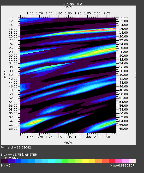
| Estimated Moho Depth: |
15.75 km |
| Estimated Crust Vp/Vs: |
2.10 |
| Assumed Crust Vp: |
6.207 km/s |
| Estimated Crust Vs: |
2.963 km/s |
| Estimated Crust Poisson's Ratio: |
0.35 |
|
| Radial Match: |
92.68042 % |
| Radial Bump: |
400 |
| Transverse Match: |
63.238453 % |
| Transverse Bump: |
400 |
| SOD ConfigId: |
24890451 |
| Insert Time: |
2021-06-02 15:24:01.494 +0000 |
| GWidth: |
2.5 |
| Max Bumps: |
400 |
| Tol: |
0.001 |
|

Signal To Noise
| Channel | StoN | STA | LTA |
| AE:X16A: :HHZ:20210513T09:49:03.258992Z | 4.814855 | 3.8620078E-7 | 8.021026E-8 |
| AE:X16A: :HHN:20210513T09:49:03.258992Z | 3.6325493 | 1.7642482E-7 | 4.8567774E-8 |
| AE:X16A: :HHE:20210513T09:49:03.258992Z | 2.2563932 | 1.7261851E-7 | 7.650197E-8 |
| Arrivals |
| Ps | 2.9 SECOND |
| PpPs | 7.4 SECOND |
| PsPs/PpSs | 10 SECOND |


