You are here: Home > Network List > XW97 - Tien Shan Continental Dynamics Stations List
> Station KHA XW.KHA > Earthquake Result Viewer
KHA XW.KHA - Earthquake Result Viewer
| Earthquake location: |
Minahassa Peninsula, Sulawesi |
| Earthquake latitude/longitude: |
0.1/123.5 |
| Earthquake time(UTC): |
1999/06/02 (153) 00:23:19 GMT |
| Earthquake Depth: |
161 km |
| Earthquake Magnitude: |
5.8 MB, 5.6 MW |
| Earthquake Catalog/Contributor: |
WHDF/NEIC |
|
| Network: |
XW Tien Shan Continental Dynamics |
| Station: |
KHA XW.KHA |
| Lat/Lon: |
44.21 N/74.00 E |
| Elevation: |
1014 m |
|
| Distance: |
62.1 deg |
| Az: |
321.786 deg |
| Baz: |
120.663 deg |
| Ray Param: |
0.05995927 |
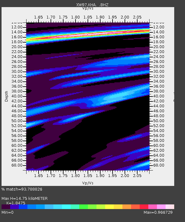
| Estimated Moho Depth: |
14.75 km |
| Estimated Crust Vp/Vs: |
1.85 |
| Assumed Crust Vp: |
6.35 km/s |
| Estimated Crust Vs: |
3.437 km/s |
| Estimated Crust Poisson's Ratio: |
0.29 |
|
| Radial Match: |
93.788826 % |
| Radial Bump: |
378 |
| Transverse Match: |
83.16329 % |
| Transverse Bump: |
400 |
| SOD ConfigId: |
4480 |
| Insert Time: |
2010-02-26 15:35:27.732 +0000 |
| GWidth: |
2.5 |
| Max Bumps: |
400 |
| Tol: |
0.001 |
|

Signal To Noise
| Channel | StoN | STA | LTA |
| XW:KHA: :BHZ:19990602T00:32:52.500029Z | 11.431353 | 7.3035017E-7 | 6.3890084E-8 |
| XW:KHA: :BHN:19990602T00:32:52.500029Z | 6.379523 | 1.4792343E-7 | 2.3187225E-8 |
| XW:KHA: :BHE:19990602T00:32:52.500029Z | 8.759479 | 2.8209143E-7 | 3.2204134E-8 |
| Arrivals |
| Ps | 2.1 SECOND |
| PpPs | 6.3 SECOND |
| PsPs/PpSs | 8.4 SECOND |


