You are here: Home > Network List > GS - US Geological Survey Networks Stations List
> Station KAN08 Anthony NE Station > Earthquake Result Viewer
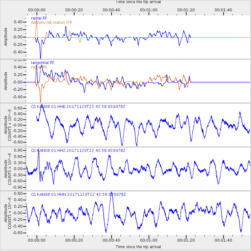
KAN08 Anthony NE Station - Earthquake Result Viewer
*The percent match for this event was below the threshold and hence no stack was calculated.
| Earthquake location: |
Kuril Islands |
| Earthquake latitude/longitude: |
45.2/146.3 |
| Earthquake time(UTC): |
2017/11/29 (333) 22:32:23 GMT |
| Earthquake Depth: |
10 km |
| Earthquake Magnitude: |
5.4 Mww |
| Earthquake Catalog/Contributor: |
NEIC PDE/us |
|
| Network: |
GS US Geological Survey Networks |
| Station: |
KAN08 Anthony NE Station |
| Lat/Lon: |
37.23 N/97.97 W |
| Elevation: |
375 m |
|
| Distance: |
79.6 deg |
| Az: |
46.968 deg |
| Baz: |
319.639 deg |
| Ray Param: |
$rayparam |
*The percent match for this event was below the threshold and hence was not used in the summary stack. |
|
| Radial Match: |
69.82366 % |
| Radial Bump: |
400 |
| Transverse Match: |
59.422756 % |
| Transverse Bump: |
400 |
| SOD ConfigId: |
2429771 |
| Insert Time: |
2017-12-13 22:34:04.871 +0000 |
| GWidth: |
2.5 |
| Max Bumps: |
400 |
| Tol: |
0.001 |
|
Signal To Noise
| Channel | StoN | STA | LTA |
| GS:KAN08:01:HHZ:20171129T22:43:58.839978Z | 1.4975541 | 3.618611E-7 | 2.4163475E-7 |
| GS:KAN08:01:HHN:20171129T22:43:58.839978Z | 1.1040107 | 2.0951589E-7 | 1.8977704E-7 |
| GS:KAN08:01:HHE:20171129T22:43:58.839978Z | 0.46942136 | 1.4095355E-7 | 3.0027084E-7 |
| Arrivals |
| Ps | |
| PpPs | |
| PsPs/PpSs | |


