You are here: Home > Network List > IU - Global Seismograph Network (GSN - IRIS/USGS) Stations List
> Station RSSD Black Hills, South Dakota, USA > Earthquake Result Viewer
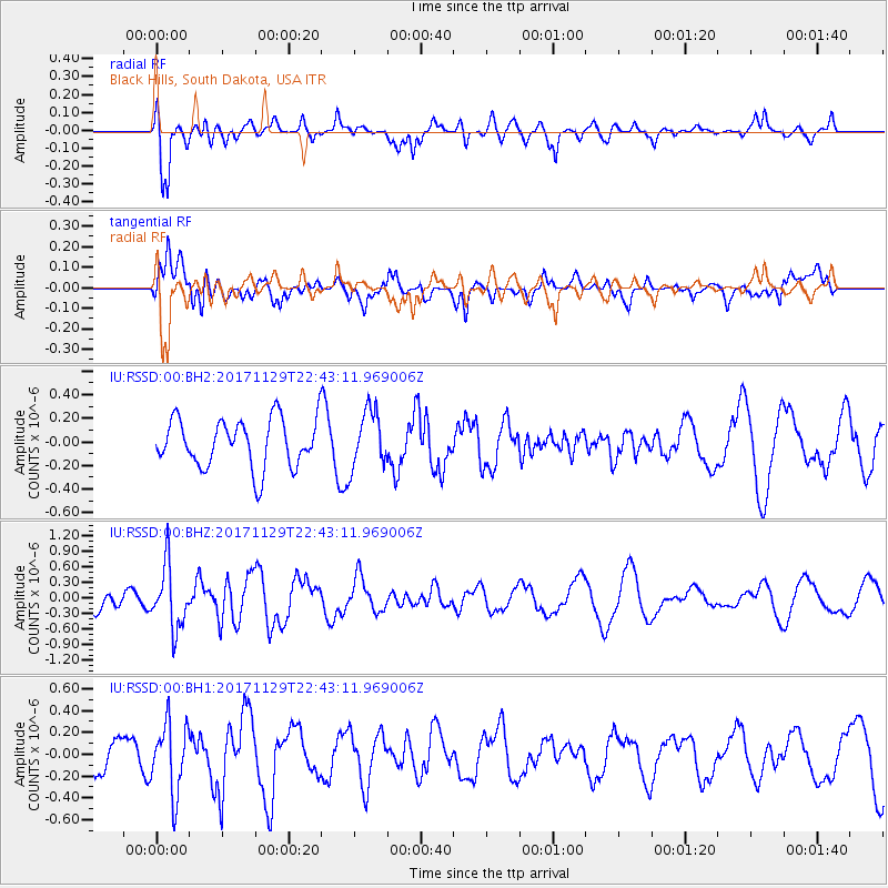
RSSD Black Hills, South Dakota, USA - Earthquake Result Viewer
*The percent match for this event was below the threshold and hence no stack was calculated.
| Earthquake location: |
Kuril Islands |
| Earthquake latitude/longitude: |
45.2/146.3 |
| Earthquake time(UTC): |
2017/11/29 (333) 22:32:23 GMT |
| Earthquake Depth: |
10 km |
| Earthquake Magnitude: |
5.4 Mww |
| Earthquake Catalog/Contributor: |
NEIC PDE/us |
|
| Network: |
IU Global Seismograph Network (GSN - IRIS/USGS) |
| Station: |
RSSD Black Hills, South Dakota, USA |
| Lat/Lon: |
44.12 N/104.04 W |
| Elevation: |
2090 m |
|
| Distance: |
71.4 deg |
| Az: |
45.684 deg |
| Baz: |
315.37 deg |
| Ray Param: |
$rayparam |
*The percent match for this event was below the threshold and hence was not used in the summary stack. |
|
| Radial Match: |
73.56563 % |
| Radial Bump: |
400 |
| Transverse Match: |
55.546932 % |
| Transverse Bump: |
400 |
| SOD ConfigId: |
2429771 |
| Insert Time: |
2017-12-13 22:35:04.327 +0000 |
| GWidth: |
2.5 |
| Max Bumps: |
400 |
| Tol: |
0.001 |
|
Signal To Noise
| Channel | StoN | STA | LTA |
| IU:RSSD:00:BHZ:20171129T22:43:11.969006Z | 1.9523807 | 5.9372877E-7 | 3.0410504E-7 |
| IU:RSSD:00:BH1:20171129T22:43:11.969006Z | 1.4799346 | 3.171732E-7 | 2.143157E-7 |
| IU:RSSD:00:BH2:20171129T22:43:11.969006Z | 1.1764988 | 2.4130986E-7 | 2.0510848E-7 |
| Arrivals |
| Ps | |
| PpPs | |
| PsPs/PpSs | |


