You are here: Home > Network List > IW - Intermountain West Stations List
> Station MOOW Moose Ponds, Wyoming, USA > Earthquake Result Viewer
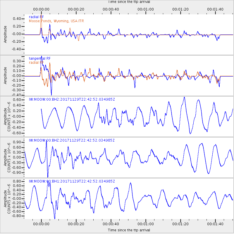
MOOW Moose Ponds, Wyoming, USA - Earthquake Result Viewer
*The percent match for this event was below the threshold and hence no stack was calculated.
| Earthquake location: |
Kuril Islands |
| Earthquake latitude/longitude: |
45.2/146.3 |
| Earthquake time(UTC): |
2017/11/29 (333) 22:32:23 GMT |
| Earthquake Depth: |
10 km |
| Earthquake Magnitude: |
5.4 Mww |
| Earthquake Catalog/Contributor: |
NEIC PDE/us |
|
| Network: |
IW Intermountain West |
| Station: |
MOOW Moose Ponds, Wyoming, USA |
| Lat/Lon: |
43.75 N/110.74 W |
| Elevation: |
2128 m |
|
| Distance: |
68.2 deg |
| Az: |
49.539 deg |
| Baz: |
312.062 deg |
| Ray Param: |
$rayparam |
*The percent match for this event was below the threshold and hence was not used in the summary stack. |
|
| Radial Match: |
64.26529 % |
| Radial Bump: |
400 |
| Transverse Match: |
81.73987 % |
| Transverse Bump: |
378 |
| SOD ConfigId: |
2429771 |
| Insert Time: |
2017-12-13 22:35:20.135 +0000 |
| GWidth: |
2.5 |
| Max Bumps: |
400 |
| Tol: |
0.001 |
|
Signal To Noise
| Channel | StoN | STA | LTA |
| IW:MOOW:00:BHZ:20171129T22:42:52.034985Z | 1.322991 | 4.989141E-7 | 3.7711075E-7 |
| IW:MOOW:00:BH1:20171129T22:42:52.034985Z | 2.2221413 | 4.834085E-7 | 2.1754175E-7 |
| IW:MOOW:00:BH2:20171129T22:42:52.034985Z | 0.92278713 | 2.538916E-7 | 2.7513565E-7 |
| Arrivals |
| Ps | |
| PpPs | |
| PsPs/PpSs | |


