You are here: Home > Network List > TA - USArray Transportable Network (new EarthScope stations) Stations List
> Station TUL3 Leonard, OK, USA > Earthquake Result Viewer
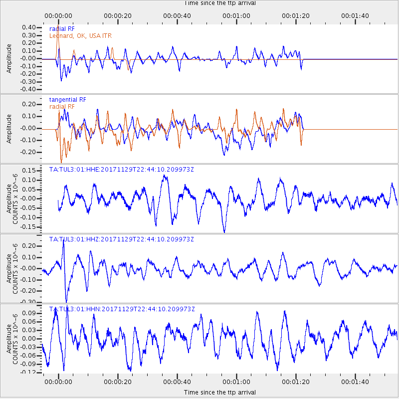
TUL3 Leonard, OK, USA - Earthquake Result Viewer
*The percent match for this event was below the threshold and hence no stack was calculated.
| Earthquake location: |
Kuril Islands |
| Earthquake latitude/longitude: |
45.2/146.3 |
| Earthquake time(UTC): |
2017/11/29 (333) 22:32:23 GMT |
| Earthquake Depth: |
10 km |
| Earthquake Magnitude: |
5.4 Mww |
| Earthquake Catalog/Contributor: |
NEIC PDE/us |
|
| Network: |
TA USArray Transportable Network (new EarthScope stations) |
| Station: |
TUL3 Leonard, OK, USA |
| Lat/Lon: |
35.91 N/95.79 W |
| Elevation: |
265 m |
|
| Distance: |
81.7 deg |
| Az: |
46.453 deg |
| Baz: |
320.849 deg |
| Ray Param: |
$rayparam |
*The percent match for this event was below the threshold and hence was not used in the summary stack. |
|
| Radial Match: |
60.577637 % |
| Radial Bump: |
400 |
| Transverse Match: |
54.566677 % |
| Transverse Bump: |
400 |
| SOD ConfigId: |
2429771 |
| Insert Time: |
2017-12-13 22:36:35.250 +0000 |
| GWidth: |
2.5 |
| Max Bumps: |
400 |
| Tol: |
0.001 |
|
Signal To Noise
| Channel | StoN | STA | LTA |
| TA:TUL3:01:HHZ:20171129T22:44:10.209973Z | 3.7026725 | 1.4029699E-7 | 3.7890736E-8 |
| TA:TUL3:01:HHN:20171129T22:44:10.209973Z | 1.5099754 | 6.47912E-8 | 4.290878E-8 |
| TA:TUL3:01:HHE:20171129T22:44:10.209973Z | 1.7556326 | 6.035286E-8 | 3.4376704E-8 |
| Arrivals |
| Ps | |
| PpPs | |
| PsPs/PpSs | |


