You are here: Home > Network List > UW - Pacific Northwest Regional Seismic Network Stations List
> Station HOOD Mt Hood Meadows, OR CREST BB SMO > Earthquake Result Viewer
HOOD Mt Hood Meadows, OR CREST BB SMO - Earthquake Result Viewer
| Earthquake location: |
South Of Panama |
| Earthquake latitude/longitude: |
6.8/-82.4 |
| Earthquake time(UTC): |
2021/05/13 (133) 09:42:12 GMT |
| Earthquake Depth: |
10 km |
| Earthquake Magnitude: |
6.0 mww |
| Earthquake Catalog/Contributor: |
NEIC PDE/us |
|
| Network: |
UW Pacific Northwest Regional Seismic Network |
| Station: |
HOOD Mt Hood Meadows, OR CREST BB SMO |
| Lat/Lon: |
45.32 N/121.65 W |
| Elevation: |
1520 m |
|
| Distance: |
51.3 deg |
| Az: |
325.097 deg |
| Baz: |
126.344 deg |
| Ray Param: |
0.0675084 |
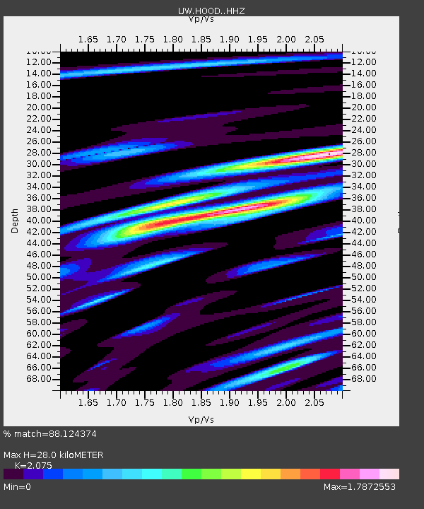
| Estimated Moho Depth: |
28.0 km |
| Estimated Crust Vp/Vs: |
2.08 |
| Assumed Crust Vp: |
6.597 km/s |
| Estimated Crust Vs: |
3.18 km/s |
| Estimated Crust Poisson's Ratio: |
0.35 |
|
| Radial Match: |
88.124374 % |
| Radial Bump: |
364 |
| Transverse Match: |
72.817856 % |
| Transverse Bump: |
382 |
| SOD ConfigId: |
24890451 |
| Insert Time: |
2021-06-02 15:50:02.548 +0000 |
| GWidth: |
2.5 |
| Max Bumps: |
400 |
| Tol: |
0.001 |
|

Signal To Noise
| Channel | StoN | STA | LTA |
| UW:HOOD: :HHZ:20210513T09:50:45.620015Z | 6.217999 | 4.8962306E-7 | 7.8742865E-8 |
| UW:HOOD: :HHN:20210513T09:50:45.620015Z | 2.1175408 | 2.9290587E-7 | 1.383236E-7 |
| UW:HOOD: :HHE:20210513T09:50:45.620015Z | 2.81733 | 3.4709043E-7 | 1.2319836E-7 |
| Arrivals |
| Ps | 4.8 SECOND |
| PpPs | 12 SECOND |
| PsPs/PpSs | 17 SECOND |


