You are here: Home > Network List > TX - Texas Seismological Network Stations List
> Station WTFS Witchita Falls > Earthquake Result Viewer
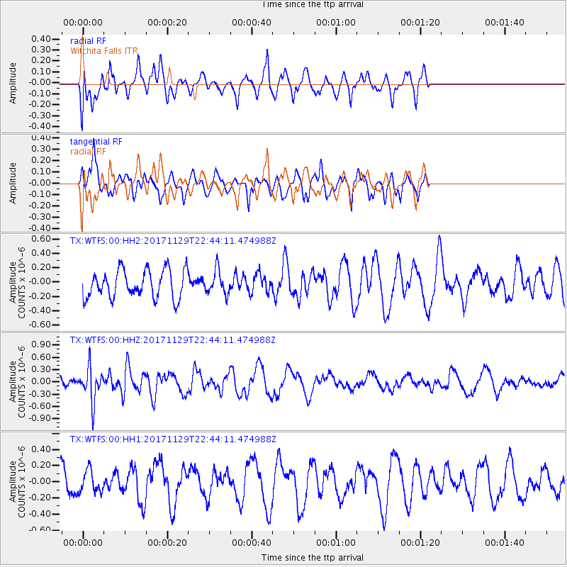
WTFS Witchita Falls - Earthquake Result Viewer
*The percent match for this event was below the threshold and hence no stack was calculated.
| Earthquake location: |
Kuril Islands |
| Earthquake latitude/longitude: |
45.2/146.3 |
| Earthquake time(UTC): |
2017/11/29 (333) 22:32:23 GMT |
| Earthquake Depth: |
10 km |
| Earthquake Magnitude: |
5.4 Mww |
| Earthquake Catalog/Contributor: |
NEIC PDE/us |
|
| Network: |
TX Texas Seismological Network |
| Station: |
WTFS Witchita Falls |
| Lat/Lon: |
33.77 N/98.46 W |
| Elevation: |
277 m |
|
| Distance: |
82.0 deg |
| Az: |
49.542 deg |
| Baz: |
319.767 deg |
| Ray Param: |
$rayparam |
*The percent match for this event was below the threshold and hence was not used in the summary stack. |
|
| Radial Match: |
58.733593 % |
| Radial Bump: |
400 |
| Transverse Match: |
72.13054 % |
| Transverse Bump: |
400 |
| SOD ConfigId: |
2429771 |
| Insert Time: |
2017-12-13 22:37:17.112 +0000 |
| GWidth: |
2.5 |
| Max Bumps: |
400 |
| Tol: |
0.001 |
|
Signal To Noise
| Channel | StoN | STA | LTA |
| TX:WTFS:00:HHZ:20171129T22:44:11.474988Z | 2.238354 | 4.0865328E-7 | 1.8256866E-7 |
| TX:WTFS:00:HH1:20171129T22:44:11.474988Z | 0.56280124 | 1.3658475E-7 | 2.4268735E-7 |
| TX:WTFS:00:HH2:20171129T22:44:11.474988Z | 0.85480154 | 1.6549656E-7 | 1.9360817E-7 |
| Arrivals |
| Ps | |
| PpPs | |
| PsPs/PpSs | |


