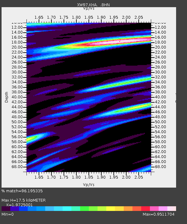
KHA XW.KHA - Earthquake Result Viewer

Earthquake location: Southern Greece
Earthquake latitude/longitude: 36.4/22.1
Earthquake time(UTC): 1997/10/13 (286) 13:39:37 GMT
Earthquake Depth: 24 km
Earthquake Magnitude: 6.2 MB, 6.6 MS, 6.7 UNKNOWN, 6.5 MW
Earthquake Catalog/Contributor: WHDF/NEIC
Network: XW Tien Shan Continental Dynamics
Station: KHA XW.KHA
Lat/Lon: 44.21 N/74.00 E
Elevation: 1014 m
Distance: 39.8 deg
Az: 62.17 deg
Baz: 277.078 deg
Ray Param: 0.074731596
Estimated Moho Depth: 17.5 km
Estimated Crust Vp/Vs: 1.97
Assumed Crust Vp: 6.35 km/s
Estimated Crust Vs: 3.219 km/s
Estimated Crust Poisson's Ratio: 0.33
Radial Match: 96.195335 %
Radial Bump: 393
Transverse Match: 88.21879 %
Transverse Bump: 400
SOD ConfigId: 6273
Insert Time: 2010-02-26 15:35:40.430 +0000
GWidth: 2.5
Max Bumps: 400
Tol: 0.001

Signal To Noise

ChannelStoNSTALTA
XW:KHA: :BHN:19971013T13:46:37.836005Z5.98680452.451047E-74.0940822E-8
XW:KHA: :BHE:19971013T13:46:37.836005Z18.5652588.03535E-74.328165E-8
XW:KHA: :BHZ:19971013T13:46:37.836005Z29.4661671.3876285E-64.7092264E-8
Arrivals
Ps2.9 SECOND
PpPs7.7 SECOND
PsPs/PpSs11 SECOND