You are here: Home > Network List > XW97 - Tien Shan Continental Dynamics Stations List
> Station KHA XW.KHA > Earthquake Result Viewer
KHA XW.KHA - Earthquake Result Viewer
| Earthquake location: |
Banda Sea |
| Earthquake latitude/longitude: |
-6.7/129.0 |
| Earthquake time(UTC): |
1997/11/03 (307) 19:17:58 GMT |
| Earthquake Depth: |
216 km |
| Earthquake Magnitude: |
5.7 MB, 6.1 UNKNOWN |
| Earthquake Catalog/Contributor: |
WHDF/NEIC |
|
| Network: |
XW Tien Shan Continental Dynamics |
| Station: |
KHA XW.KHA |
| Lat/Lon: |
44.21 N/74.00 E |
| Elevation: |
1014 m |
|
| Distance: |
70.8 deg |
| Az: |
321.4 deg |
| Baz: |
120.502 deg |
| Ray Param: |
0.054127548 |
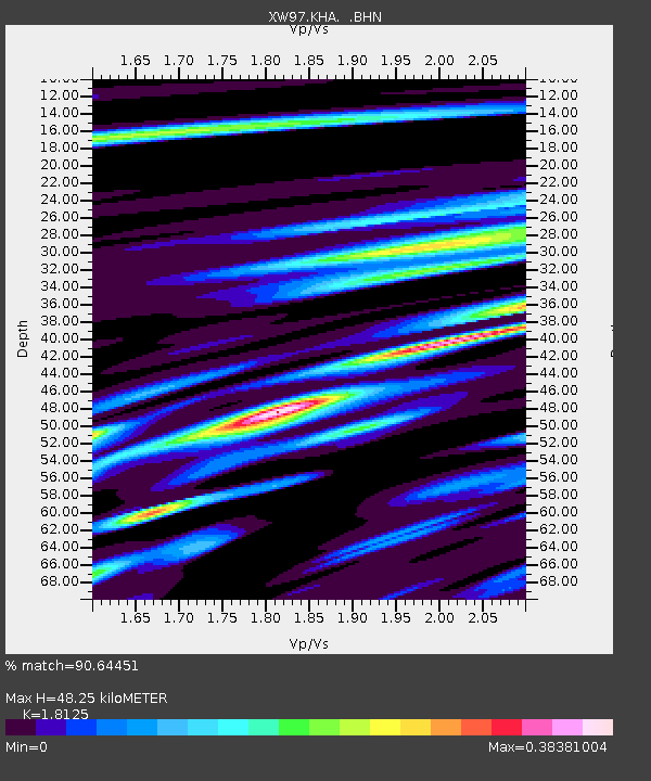
| Estimated Moho Depth: |
48.25 km |
| Estimated Crust Vp/Vs: |
1.81 |
| Assumed Crust Vp: |
6.35 km/s |
| Estimated Crust Vs: |
3.503 km/s |
| Estimated Crust Poisson's Ratio: |
0.28 |
|
| Radial Match: |
90.64451 % |
| Radial Bump: |
400 |
| Transverse Match: |
71.412605 % |
| Transverse Bump: |
400 |
| SOD ConfigId: |
6273 |
| Insert Time: |
2010-02-26 15:35:44.292 +0000 |
| GWidth: |
2.5 |
| Max Bumps: |
400 |
| Tol: |
0.001 |
|

Signal To Noise
| Channel | StoN | STA | LTA |
| XW:KHA: :BHN:19971103T19:28:20.980017Z | 1.3505619 | 6.791855E-8 | 5.0289106E-8 |
| XW:KHA: :BHE:19971103T19:28:20.980017Z | 4.0476365 | 1.3752431E-7 | 3.3976452E-8 |
| XW:KHA: :BHZ:19971103T19:28:20.980017Z | 4.6336236 | 3.706537E-7 | 7.99922E-8 |
| Arrivals |
| Ps | 6.4 SECOND |
| PpPs | 21 SECOND |
| PsPs/PpSs | 27 SECOND |


