You are here: Home > Network List > XH94 - Colorado Plateau-Great Basin Network Stations List
> Station CYF Cyclone Flat, Utah > Earthquake Result Viewer
CYF Cyclone Flat, Utah - Earthquake Result Viewer
| Earthquake location: |
Greece |
| Earthquake latitude/longitude: |
40.1/21.7 |
| Earthquake time(UTC): |
1995/05/13 (133) 08:47:12 GMT |
| Earthquake Depth: |
13 km |
| Earthquake Magnitude: |
6.2 MB, 6.5 MS, 6.6 UNKNOWN, 6.5 MD |
| Earthquake Catalog/Contributor: |
WHDF/NEIC |
|
| Network: |
XH Colorado Plateau-Great Basin Network |
| Station: |
CYF Cyclone Flat, Utah |
| Lat/Lon: |
37.55 N/109.87 W |
| Elevation: |
2057 m |
|
| Distance: |
90.8 deg |
| Az: |
323.499 deg |
| Baz: |
35.011 deg |
| Ray Param: |
0.04164563 |
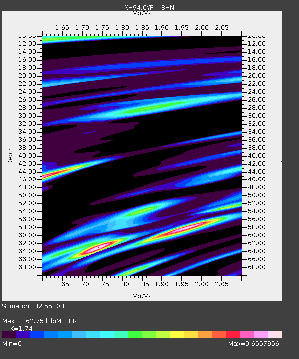
| Estimated Moho Depth: |
62.75 km |
| Estimated Crust Vp/Vs: |
1.74 |
| Assumed Crust Vp: |
6.476 km/s |
| Estimated Crust Vs: |
3.722 km/s |
| Estimated Crust Poisson's Ratio: |
0.25 |
|
| Radial Match: |
82.55103 % |
| Radial Bump: |
400 |
| Transverse Match: |
54.19315 % |
| Transverse Bump: |
400 |
| SOD ConfigId: |
6273 |
| Insert Time: |
2010-03-09 08:16:46.969 +0000 |
| GWidth: |
2.5 |
| Max Bumps: |
400 |
| Tol: |
0.001 |
|

Signal To Noise
| Channel | StoN | STA | LTA |
| XH:CYF: :BHN:19950513T08:59:43.930017Z | 1.5450178 | 2.0477E-7 | 1.3253569E-7 |
| XH:CYF: :BHE:19950513T08:59:43.930017Z | 2.072634 | 2.196228E-7 | 1.0596314E-7 |
| XH:CYF: :BHZ:19950513T08:59:43.930017Z | 6.090668 | 6.4132735E-7 | 1.05296714E-7 |
| Arrivals |
| Ps | 7.3 SECOND |
| PpPs | 26 SECOND |
| PsPs/PpSs | 33 SECOND |


