You are here: Home > Network List > US - United States National Seismic Network Stations List
> Station MNTX Cornudas Mountains, Texas, USA > Earthquake Result Viewer
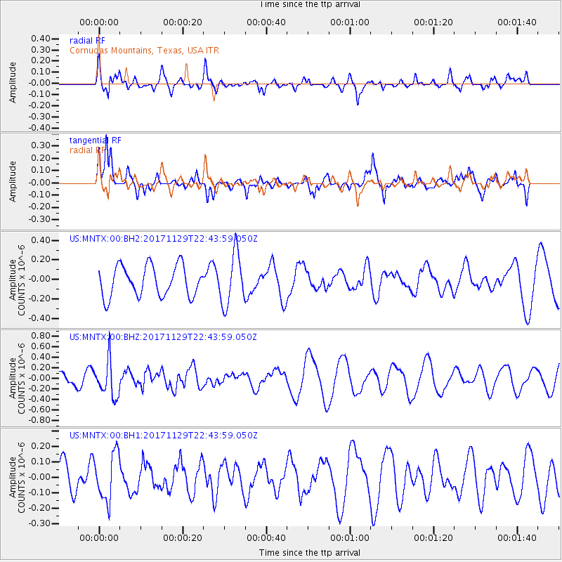
MNTX Cornudas Mountains, Texas, USA - Earthquake Result Viewer
*The percent match for this event was below the threshold and hence no stack was calculated.
| Earthquake location: |
Kuril Islands |
| Earthquake latitude/longitude: |
45.2/146.3 |
| Earthquake time(UTC): |
2017/11/29 (333) 22:32:23 GMT |
| Earthquake Depth: |
10 km |
| Earthquake Magnitude: |
5.4 Mww |
| Earthquake Catalog/Contributor: |
NEIC PDE/us |
|
| Network: |
US United States National Seismic Network |
| Station: |
MNTX Cornudas Mountains, Texas, USA |
| Lat/Lon: |
31.70 N/105.38 W |
| Elevation: |
404 m |
|
| Distance: |
79.6 deg |
| Az: |
55.342 deg |
| Baz: |
316.969 deg |
| Ray Param: |
$rayparam |
*The percent match for this event was below the threshold and hence was not used in the summary stack. |
|
| Radial Match: |
60.13554 % |
| Radial Bump: |
400 |
| Transverse Match: |
67.72508 % |
| Transverse Bump: |
400 |
| SOD ConfigId: |
2429771 |
| Insert Time: |
2017-12-13 22:38:13.141 +0000 |
| GWidth: |
2.5 |
| Max Bumps: |
400 |
| Tol: |
0.001 |
|
Signal To Noise
| Channel | StoN | STA | LTA |
| US:MNTX:00:BHZ:20171129T22:43:59.050Z | 2.3317988 | 3.4412514E-7 | 1.4757926E-7 |
| US:MNTX:00:BH1:20171129T22:43:59.050Z | 1.5690256 | 1.5631129E-7 | 9.962316E-8 |
| US:MNTX:00:BH2:20171129T22:43:59.050Z | 1.7455112 | 2.7233844E-7 | 1.5602215E-7 |
| Arrivals |
| Ps | |
| PpPs | |
| PsPs/PpSs | |


