You are here: Home > Network List > US - United States National Seismic Network Stations List
> Station OGNE Ogallala, Nebraska, USA > Earthquake Result Viewer
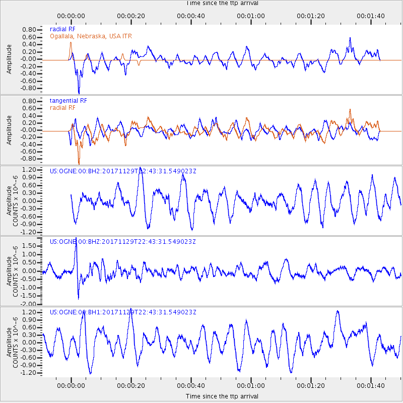
OGNE Ogallala, Nebraska, USA - Earthquake Result Viewer
*The percent match for this event was below the threshold and hence no stack was calculated.
| Earthquake location: |
Kuril Islands |
| Earthquake latitude/longitude: |
45.2/146.3 |
| Earthquake time(UTC): |
2017/11/29 (333) 22:32:23 GMT |
| Earthquake Depth: |
10 km |
| Earthquake Magnitude: |
5.4 Mww |
| Earthquake Catalog/Contributor: |
NEIC PDE/us |
|
| Network: |
US United States National Seismic Network |
| Station: |
OGNE Ogallala, Nebraska, USA |
| Lat/Lon: |
40.95 N/102.03 W |
| Elevation: |
1054 m |
|
| Distance: |
74.7 deg |
| Az: |
46.862 deg |
| Baz: |
317.063 deg |
| Ray Param: |
$rayparam |
*The percent match for this event was below the threshold and hence was not used in the summary stack. |
|
| Radial Match: |
49.18312 % |
| Radial Bump: |
400 |
| Transverse Match: |
58.090973 % |
| Transverse Bump: |
400 |
| SOD ConfigId: |
2429771 |
| Insert Time: |
2017-12-13 22:38:22.257 +0000 |
| GWidth: |
2.5 |
| Max Bumps: |
400 |
| Tol: |
0.001 |
|
Signal To Noise
| Channel | StoN | STA | LTA |
| US:OGNE:00:BHZ:20171129T22:43:31.549023Z | 5.00919 | 7.684477E-7 | 1.5340758E-7 |
| US:OGNE:00:BH1:20171129T22:43:31.549023Z | 1.825165 | 6.4907056E-7 | 3.5562294E-7 |
| US:OGNE:00:BH2:20171129T22:43:31.549023Z | 0.8599259 | 3.5791305E-7 | 4.162138E-7 |
| Arrivals |
| Ps | |
| PpPs | |
| PsPs/PpSs | |


