You are here: Home > Network List > XH94 - Colorado Plateau-Great Basin Network Stations List
> Station GAR Garrison, Utah-Nevada border > Earthquake Result Viewer
GAR Garrison, Utah-Nevada border - Earthquake Result Viewer
| Earthquake location: |
Kuril Islands |
| Earthquake latitude/longitude: |
43.3/146.7 |
| Earthquake time(UTC): |
1995/01/21 (021) 08:47:29 GMT |
| Earthquake Depth: |
63 km |
| Earthquake Magnitude: |
6.5 MB, 6.6 UNKNOWN, 6.4 MW |
| Earthquake Catalog/Contributor: |
WHDF/NEIC |
|
| Network: |
XH Colorado Plateau-Great Basin Network |
| Station: |
GAR Garrison, Utah-Nevada border |
| Lat/Lon: |
38.88 N/114.10 W |
| Elevation: |
1977 m |
|
| Distance: |
70.3 deg |
| Az: |
54.911 deg |
| Baz: |
310.098 deg |
| Ray Param: |
0.05491714 |
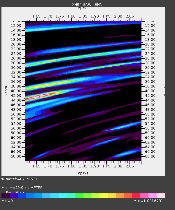
| Estimated Moho Depth: |
42.0 km |
| Estimated Crust Vp/Vs: |
1.66 |
| Assumed Crust Vp: |
6.276 km/s |
| Estimated Crust Vs: |
3.775 km/s |
| Estimated Crust Poisson's Ratio: |
0.22 |
|
| Radial Match: |
87.78611 % |
| Radial Bump: |
400 |
| Transverse Match: |
69.071495 % |
| Transverse Bump: |
400 |
| SOD ConfigId: |
6273 |
| Insert Time: |
2010-03-09 08:17:38.896 +0000 |
| GWidth: |
2.5 |
| Max Bumps: |
400 |
| Tol: |
0.001 |
|

Signal To Noise
| Channel | StoN | STA | LTA |
| XH:GAR: :BHN:19950121T08:58:06.014014Z | 3.597042 | 1.1099099E-6 | 3.0856185E-7 |
| XH:GAR: :BHE:19950121T08:58:06.014014Z | 2.3611279 | 7.712939E-7 | 3.2666333E-7 |
| XH:GAR: :BHZ:19950121T08:58:06.014014Z | 6.6217875 | 3.0604558E-6 | 4.621797E-7 |
| Arrivals |
| Ps | 4.6 SECOND |
| PpPs | 17 SECOND |
| PsPs/PpSs | 22 SECOND |


