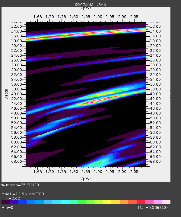
KHA XW.KHA - Earthquake Result Viewer

Earthquake location: Banda Sea
Earthquake latitude/longitude: -4.5/129.1
Earthquake time(UTC): 1998/02/19 (050) 14:14:51 GMT
Earthquake Depth: 33 km
Earthquake Magnitude: 6.1 MB, 6.4 MS, 6.5 UNKNOWN, 6.5 MW
Earthquake Catalog/Contributor: WHDF/NEIC
Network: XW Tien Shan Continental Dynamics
Station: KHA XW.KHA
Lat/Lon: 44.21 N/74.00 E
Elevation: 1014 m
Distance: 69.1 deg
Az: 320.863 deg
Baz: 118.952 deg
Ray Param: 0.055811297
Estimated Moho Depth: 13.5 km
Estimated Crust Vp/Vs: 2.02
Assumed Crust Vp: 6.35 km/s
Estimated Crust Vs: 3.144 km/s
Estimated Crust Poisson's Ratio: 0.34
Radial Match: 95.98628 %
Radial Bump: 271
Transverse Match: 79.330536 %
Transverse Bump: 400
SOD ConfigId: 6273
Insert Time: 2010-02-26 15:35:50.675 +0000
GWidth: 2.5
Max Bumps: 400
Tol: 0.001

Signal To Noise

ChannelStoNSTALTA
XW:KHA: :BHN:19980219T14:25:23.050012Z3.62449482.277016E-76.282299E-8
XW:KHA: :BHE:19980219T14:25:23.050012Z13.2355455.365193E-74.0536246E-8
XW:KHA: :BHZ:19980219T14:25:23.050012Z26.1282521.5116992E-65.785688E-8
Arrivals
Ps2.2 SECOND
PpPs6.2 SECOND
PsPs/PpSs8.5 SECOND