You are here: Home > Network List > US - United States National Seismic Network Stations List
> Station EGMT Eagleton, Montana, USA > Earthquake Result Viewer
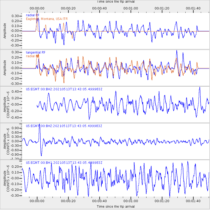
EGMT Eagleton, Montana, USA - Earthquake Result Viewer
*The percent match for this event was below the threshold and hence no stack was calculated.
| Earthquake location: |
Fiji Islands Region |
| Earthquake latitude/longitude: |
-15.9/-177.4 |
| Earthquake time(UTC): |
2021/05/13 (133) 13:31:35 GMT |
| Earthquake Depth: |
424 km |
| Earthquake Magnitude: |
5.7 Mww |
| Earthquake Catalog/Contributor: |
NEIC PDE/us |
|
| Network: |
US United States National Seismic Network |
| Station: |
EGMT Eagleton, Montana, USA |
| Lat/Lon: |
48.02 N/109.75 W |
| Elevation: |
1055 m |
|
| Distance: |
87.5 deg |
| Az: |
38.434 deg |
| Baz: |
242.978 deg |
| Ray Param: |
$rayparam |
*The percent match for this event was below the threshold and hence was not used in the summary stack. |
|
| Radial Match: |
60.87257 % |
| Radial Bump: |
400 |
| Transverse Match: |
66.48349 % |
| Transverse Bump: |
400 |
| SOD ConfigId: |
24890451 |
| Insert Time: |
2021-06-02 16:15:25.953 +0000 |
| GWidth: |
2.5 |
| Max Bumps: |
400 |
| Tol: |
0.001 |
|
Signal To Noise
| Channel | StoN | STA | LTA |
| US:EGMT:00:BHZ:20210513T13:43:05.499983Z | 5.1317487 | 5.077378E-7 | 9.894051E-8 |
| US:EGMT:00:BH1:20210513T13:43:05.499983Z | 0.82766277 | 9.6051316E-8 | 1.1605127E-7 |
| US:EGMT:00:BH2:20210513T13:43:05.499983Z | 1.5542645 | 1.9910308E-7 | 1.2810116E-7 |
| Arrivals |
| Ps | |
| PpPs | |
| PsPs/PpSs | |


