You are here: Home > Network List > US - United States National Seismic Network Stations List
> Station NATX Nacogdoches, Texas, USA > Earthquake Result Viewer
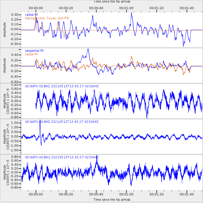
NATX Nacogdoches, Texas, USA - Earthquake Result Viewer
*The percent match for this event was below the threshold and hence no stack was calculated.
| Earthquake location: |
Fiji Islands Region |
| Earthquake latitude/longitude: |
-15.9/-177.4 |
| Earthquake time(UTC): |
2021/05/13 (133) 13:31:35 GMT |
| Earthquake Depth: |
424 km |
| Earthquake Magnitude: |
5.7 Mww |
| Earthquake Catalog/Contributor: |
NEIC PDE/us |
|
| Network: |
US United States National Seismic Network |
| Station: |
NATX Nacogdoches, Texas, USA |
| Lat/Lon: |
31.76 N/94.66 W |
| Elevation: |
168 m |
|
| Distance: |
92.3 deg |
| Az: |
57.754 deg |
| Baz: |
252.781 deg |
| Ray Param: |
$rayparam |
*The percent match for this event was below the threshold and hence was not used in the summary stack. |
|
| Radial Match: |
43.240204 % |
| Radial Bump: |
400 |
| Transverse Match: |
45.24645 % |
| Transverse Bump: |
400 |
| SOD ConfigId: |
24890451 |
| Insert Time: |
2021-06-02 16:15:42.553 +0000 |
| GWidth: |
2.5 |
| Max Bumps: |
400 |
| Tol: |
0.001 |
|
Signal To Noise
| Channel | StoN | STA | LTA |
| US:NATX:00:BHZ:20210513T13:43:27.423994Z | 3.4190576 | 5.373427E-7 | 1.5716107E-7 |
| US:NATX:00:BH1:20210513T13:43:27.423994Z | 1.409627 | 2.613931E-7 | 1.8543425E-7 |
| US:NATX:00:BH2:20210513T13:43:27.423994Z | 0.7704793 | 1.9543651E-7 | 2.5365574E-7 |
| Arrivals |
| Ps | |
| PpPs | |
| PsPs/PpSs | |


