You are here: Home > Network List > XH94 - Colorado Plateau-Great Basin Network Stations List
> Station LMP Lampstand, Utah > Earthquake Result Viewer
LMP Lampstand, Utah - Earthquake Result Viewer
| Earthquake location: |
Leeward Islands |
| Earthquake latitude/longitude: |
16.6/-59.6 |
| Earthquake time(UTC): |
1995/03/08 (067) 03:45:59 GMT |
| Earthquake Depth: |
15 km |
| Earthquake Magnitude: |
6.3 MB, 6.2 MS, 6.4 UNKNOWN, 6.1 MD |
| Earthquake Catalog/Contributor: |
WHDF/NEIC |
|
| Network: |
XH Colorado Plateau-Great Basin Network |
| Station: |
LMP Lampstand, Utah |
| Lat/Lon: |
37.98 N/111.20 W |
| Elevation: |
1922 m |
|
| Distance: |
49.9 deg |
| Az: |
305.92 deg |
| Baz: |
100.629 deg |
| Ray Param: |
0.06839167 |
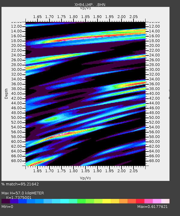
| Estimated Moho Depth: |
57.0 km |
| Estimated Crust Vp/Vs: |
1.74 |
| Assumed Crust Vp: |
6.247 km/s |
| Estimated Crust Vs: |
3.595 km/s |
| Estimated Crust Poisson's Ratio: |
0.25 |
|
| Radial Match: |
95.21642 % |
| Radial Bump: |
363 |
| Transverse Match: |
84.35232 % |
| Transverse Bump: |
400 |
| SOD ConfigId: |
6273 |
| Insert Time: |
2010-03-09 08:18:32.252 +0000 |
| GWidth: |
2.5 |
| Max Bumps: |
400 |
| Tol: |
0.001 |
|

Signal To Noise
| Channel | StoN | STA | LTA |
| XH:LMP: :BHN:19950308T03:54:21.575Z | 1.1114639 | 1.2429857E-7 | 1.118332E-7 |
| XH:LMP: :BHE:19950308T03:54:21.575Z | 1.4617223 | 1.9222483E-7 | 1.3150571E-7 |
| XH:LMP: :BHZ:19950308T03:54:21.575Z | 4.040651 | 6.172544E-7 | 1.5276113E-7 |
| Arrivals |
| Ps | 7.1 SECOND |
| PpPs | 24 SECOND |
| PsPs/PpSs | 31 SECOND |


