You are here: Home > Network List > AK - Alaska Regional Network Stations List
> Station A19K Wainwright, AK, USA > Earthquake Result Viewer
A19K Wainwright, AK, USA - Earthquake Result Viewer
| Earthquake location: |
Near East Coast Of Honshu, Japan |
| Earthquake latitude/longitude: |
37.7/141.8 |
| Earthquake time(UTC): |
2021/05/13 (133) 23:58:14 GMT |
| Earthquake Depth: |
32 km |
| Earthquake Magnitude: |
6.0 mww |
| Earthquake Catalog/Contributor: |
NEIC PDE/us |
|
| Network: |
AK Alaska Regional Network |
| Station: |
A19K Wainwright, AK, USA |
| Lat/Lon: |
70.20 N/161.07 W |
| Elevation: |
24 m |
|
| Distance: |
44.0 deg |
| Az: |
24.326 deg |
| Baz: |
253.53 deg |
| Ray Param: |
0.07213165 |
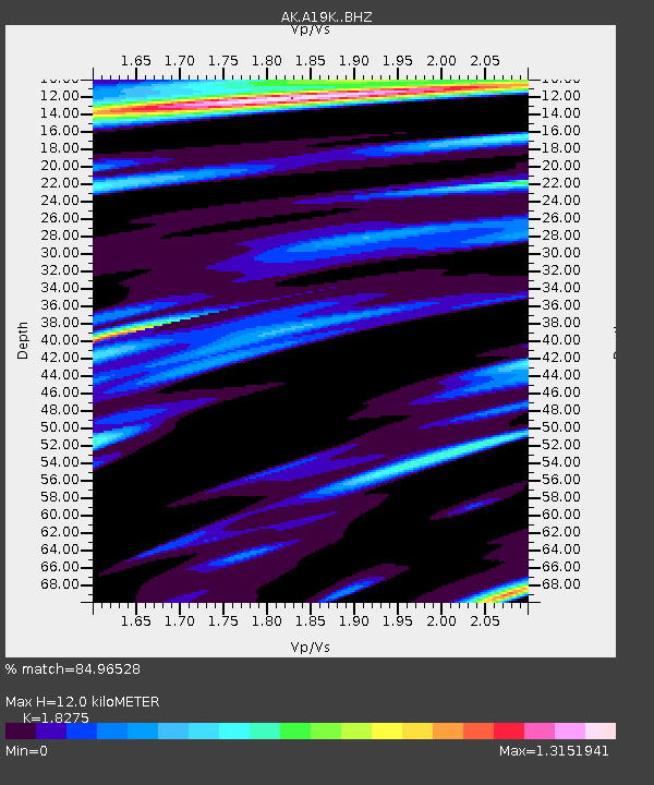
| Estimated Moho Depth: |
12.0 km |
| Estimated Crust Vp/Vs: |
1.83 |
| Assumed Crust Vp: |
5.989 km/s |
| Estimated Crust Vs: |
3.277 km/s |
| Estimated Crust Poisson's Ratio: |
0.29 |
|
| Radial Match: |
84.96528 % |
| Radial Bump: |
400 |
| Transverse Match: |
68.94923 % |
| Transverse Bump: |
400 |
| SOD ConfigId: |
24890451 |
| Insert Time: |
2021-06-02 16:23:12.036 +0000 |
| GWidth: |
2.5 |
| Max Bumps: |
400 |
| Tol: |
0.001 |
|

Signal To Noise
| Channel | StoN | STA | LTA |
| AK:A19K: :BHZ:20210514T00:05:47.979998Z | 14.904623 | 1.8625973E-6 | 1.2496776E-7 |
| AK:A19K: :BHN:20210514T00:05:47.979998Z | 1.9572283 | 1.8870735E-7 | 9.6415604E-8 |
| AK:A19K: :BHE:20210514T00:05:47.979998Z | 5.327413 | 5.8093804E-7 | 1.0904694E-7 |
| Arrivals |
| Ps | 1.8 SECOND |
| PpPs | 5.4 SECOND |
| PsPs/PpSs | 7.1 SECOND |


