You are here: Home > Network List > XH94 - Colorado Plateau-Great Basin Network Stations List
> Station MDW Meadow, Utah > Earthquake Result Viewer
MDW Meadow, Utah - Earthquake Result Viewer
| Earthquake location: |
Kuril Islands |
| Earthquake latitude/longitude: |
44.1/148.1 |
| Earthquake time(UTC): |
1995/04/28 (118) 16:30:00 GMT |
| Earthquake Depth: |
29 km |
| Earthquake Magnitude: |
6.6 MB, 6.9 MS, 7.0 UNKNOWN, 6.8 MW |
| Earthquake Catalog/Contributor: |
WHDF/NEIC |
|
| Network: |
XH Colorado Plateau-Great Basin Network |
| Station: |
MDW Meadow, Utah |
| Lat/Lon: |
38.89 N/112.36 W |
| Elevation: |
1640 m |
|
| Distance: |
70.1 deg |
| Az: |
54.895 deg |
| Baz: |
310.903 deg |
| Ray Param: |
0.055135123 |
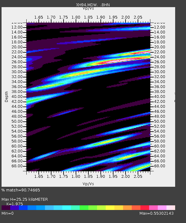
| Estimated Moho Depth: |
25.25 km |
| Estimated Crust Vp/Vs: |
1.98 |
| Assumed Crust Vp: |
6.276 km/s |
| Estimated Crust Vs: |
3.178 km/s |
| Estimated Crust Poisson's Ratio: |
0.33 |
|
| Radial Match: |
90.74665 % |
| Radial Bump: |
400 |
| Transverse Match: |
74.47619 % |
| Transverse Bump: |
400 |
| SOD ConfigId: |
6273 |
| Insert Time: |
2010-03-09 08:19:24.285 +0000 |
| GWidth: |
2.5 |
| Max Bumps: |
400 |
| Tol: |
0.001 |
|

Signal To Noise
| Channel | StoN | STA | LTA |
| XH:MDW: :BHN:19950428T16:40:39.416003Z | 1.4379183 | 1.9681642E-7 | 1.3687594E-7 |
| XH:MDW: :BHE:19950428T16:40:39.416003Z | 0.783091 | 1.376314E-7 | 1.7575404E-7 |
| XH:MDW: :BHZ:19950428T16:40:39.416003Z | 1.4163686 | 3.218069E-7 | 2.2720563E-7 |
| Arrivals |
| Ps | 4.0 SECOND |
| PpPs | 12 SECOND |
| PsPs/PpSs | 16 SECOND |


