You are here: Home > Network List > XH94 - Colorado Plateau-Great Basin Network Stations List
> Station MDW Meadow, Utah > Earthquake Result Viewer
MDW Meadow, Utah - Earthquake Result Viewer
| Earthquake location: |
Colombia |
| Earthquake latitude/longitude: |
4.2/-76.6 |
| Earthquake time(UTC): |
1995/02/08 (039) 18:40:25 GMT |
| Earthquake Depth: |
69 km |
| Earthquake Magnitude: |
6.3 MB, 6.4 UNKNOWN, 6.0 MD |
| Earthquake Catalog/Contributor: |
WHDF/NEIC |
|
| Network: |
XH Colorado Plateau-Great Basin Network |
| Station: |
MDW Meadow, Utah |
| Lat/Lon: |
38.89 N/112.36 W |
| Elevation: |
1640 m |
|
| Distance: |
47.4 deg |
| Az: |
321.758 deg |
| Baz: |
127.709 deg |
| Ray Param: |
0.069818355 |
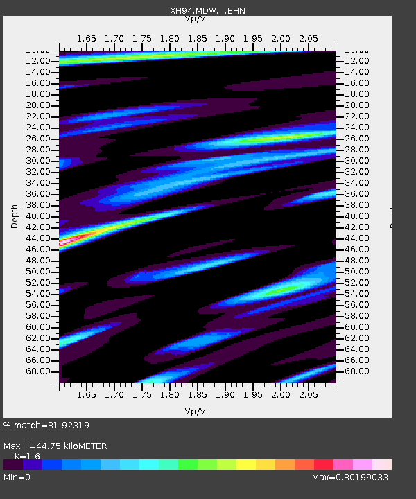
| Estimated Moho Depth: |
44.75 km |
| Estimated Crust Vp/Vs: |
1.60 |
| Assumed Crust Vp: |
6.276 km/s |
| Estimated Crust Vs: |
3.922 km/s |
| Estimated Crust Poisson's Ratio: |
0.18 |
|
| Radial Match: |
81.92319 % |
| Radial Bump: |
400 |
| Transverse Match: |
80.55654 % |
| Transverse Bump: |
400 |
| SOD ConfigId: |
6273 |
| Insert Time: |
2010-03-09 08:19:32.050 +0000 |
| GWidth: |
2.5 |
| Max Bumps: |
400 |
| Tol: |
0.001 |
|

Signal To Noise
| Channel | StoN | STA | LTA |
| XH:MDW: :BHN:19950208T18:48:21.885004Z | 13.361309 | 1.0085868E-6 | 7.548562E-8 |
| XH:MDW: :BHE:19950208T18:48:21.885004Z | 10.881925 | 1.4438388E-6 | 1.326823E-7 |
| XH:MDW: :BHZ:19950208T18:48:21.885004Z | 19.270153 | 3.0501124E-6 | 1.582817E-7 |
| Arrivals |
| Ps | 4.6 SECOND |
| PpPs | 17 SECOND |
| PsPs/PpSs | 22 SECOND |


