You are here: Home > Network List > CU - Caribbean Network (USGS) Stations List
> Station BBGH Gun Hill, Barbados > Earthquake Result Viewer
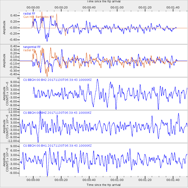
BBGH Gun Hill, Barbados - Earthquake Result Viewer
*The percent match for this event was below the threshold and hence no stack was calculated.
| Earthquake location: |
Central Mid-Atlantic Ridge |
| Earthquake latitude/longitude: |
-1.1/-23.5 |
| Earthquake time(UTC): |
2017/11/30 (334) 06:32:52 GMT |
| Earthquake Depth: |
10 km |
| Earthquake Magnitude: |
6.5 Mi |
| Earthquake Catalog/Contributor: |
NEIC PDE/at |
|
| Network: |
CU Caribbean Network (USGS) |
| Station: |
BBGH Gun Hill, Barbados |
| Lat/Lon: |
13.14 N/59.56 W |
| Elevation: |
180 m |
|
| Distance: |
38.5 deg |
| Az: |
292.79 deg |
| Baz: |
108.875 deg |
| Ray Param: |
$rayparam |
*The percent match for this event was below the threshold and hence was not used in the summary stack. |
|
| Radial Match: |
74.50583 % |
| Radial Bump: |
400 |
| Transverse Match: |
58.848938 % |
| Transverse Bump: |
400 |
| SOD ConfigId: |
2429771 |
| Insert Time: |
2017-12-14 06:35:46.046 +0000 |
| GWidth: |
2.5 |
| Max Bumps: |
400 |
| Tol: |
0.001 |
|
Signal To Noise
| Channel | StoN | STA | LTA |
| CU:BBGH:00:BHZ:20171130T06:39:43.100006Z | 2.2375371 | 5.2748364E-6 | 2.3574296E-6 |
| CU:BBGH:00:BH1:20171130T06:39:43.100006Z | 0.70595443 | 1.4831501E-6 | 2.1009148E-6 |
| CU:BBGH:00:BH2:20171130T06:39:43.100006Z | 1.2549974 | 2.578441E-6 | 2.054539E-6 |
| Arrivals |
| Ps | |
| PpPs | |
| PsPs/PpSs | |


