You are here: Home > Network List > CC - Cascade Chain Volcano Monitoring Stations List
> Station PR01 Puyallup River 01 > Earthquake Result Viewer
PR01 Puyallup River 01 - Earthquake Result Viewer
| Earthquake location: |
Near East Coast Of Honshu, Japan |
| Earthquake latitude/longitude: |
37.7/141.8 |
| Earthquake time(UTC): |
2021/05/13 (133) 23:58:14 GMT |
| Earthquake Depth: |
32 km |
| Earthquake Magnitude: |
6.0 mww |
| Earthquake Catalog/Contributor: |
NEIC PDE/us |
|
| Network: |
CC Cascade Chain Volcano Monitoring |
| Station: |
PR01 Puyallup River 01 |
| Lat/Lon: |
46.91 N/122.04 W |
| Elevation: |
648 m |
|
| Distance: |
67.4 deg |
| Az: |
47.601 deg |
| Baz: |
301.318 deg |
| Ray Param: |
0.056966048 |
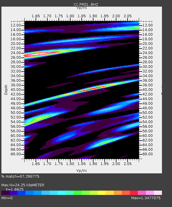
| Estimated Moho Depth: |
24.25 km |
| Estimated Crust Vp/Vs: |
1.66 |
| Assumed Crust Vp: |
6.566 km/s |
| Estimated Crust Vs: |
3.95 km/s |
| Estimated Crust Poisson's Ratio: |
0.22 |
|
| Radial Match: |
87.298775 % |
| Radial Bump: |
400 |
| Transverse Match: |
78.38314 % |
| Transverse Bump: |
400 |
| SOD ConfigId: |
24890451 |
| Insert Time: |
2021-06-02 16:28:04.247 +0000 |
| GWidth: |
2.5 |
| Max Bumps: |
400 |
| Tol: |
0.001 |
|

Signal To Noise
| Channel | StoN | STA | LTA |
| CC:PR01: :BHZ:20210514T00:08:35.18001Z | 7.9376183 | 7.9225543E-7 | 9.9810215E-8 |
| CC:PR01: :BHN:20210514T00:08:35.18001Z | 1.266401 | 1.8191729E-7 | 1.4364902E-7 |
| CC:PR01: :BHE:20210514T00:08:35.18001Z | 2.5573945 | 3.0468365E-7 | 1.191383E-7 |
| Arrivals |
| Ps | 2.6 SECOND |
| PpPs | 9.4 SECOND |
| PsPs/PpSs | 12 SECOND |


