You are here: Home > Network List > CI - Caltech Regional Seismic Network Stations List
> Station MPP McPhearson Peak > Earthquake Result Viewer
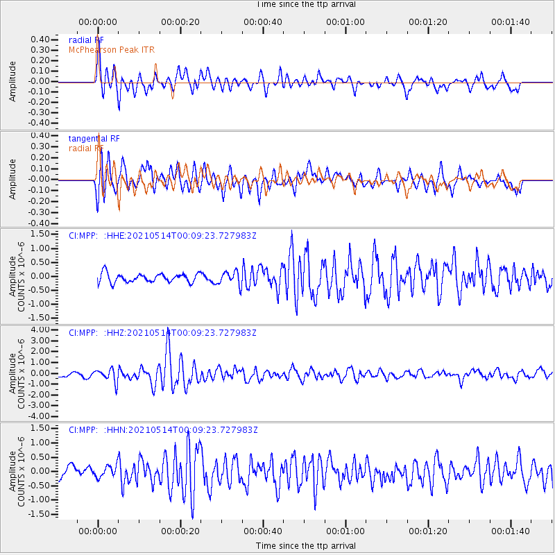
MPP McPhearson Peak - Earthquake Result Viewer
*The percent match for this event was below the threshold and hence no stack was calculated.
| Earthquake location: |
Near East Coast Of Honshu, Japan |
| Earthquake latitude/longitude: |
37.7/141.8 |
| Earthquake time(UTC): |
2021/05/13 (133) 23:58:14 GMT |
| Earthquake Depth: |
32 km |
| Earthquake Magnitude: |
6.0 mww |
| Earthquake Catalog/Contributor: |
NEIC PDE/us |
|
| Network: |
CI Caltech Regional Seismic Network |
| Station: |
MPP McPhearson Peak |
| Lat/Lon: |
34.89 N/119.81 W |
| Elevation: |
1739 m |
|
| Distance: |
75.4 deg |
| Az: |
57.164 deg |
| Baz: |
305.841 deg |
| Ray Param: |
$rayparam |
*The percent match for this event was below the threshold and hence was not used in the summary stack. |
|
| Radial Match: |
78.04283 % |
| Radial Bump: |
400 |
| Transverse Match: |
79.43222 % |
| Transverse Bump: |
400 |
| SOD ConfigId: |
24890451 |
| Insert Time: |
2021-06-02 16:30:00.138 +0000 |
| GWidth: |
2.5 |
| Max Bumps: |
400 |
| Tol: |
0.001 |
|
Signal To Noise
| Channel | StoN | STA | LTA |
| CI:MPP: :HHZ:20210514T00:09:23.727983Z | 2.3261836 | 6.2161274E-7 | 2.672243E-7 |
| CI:MPP: :HHN:20210514T00:09:23.727983Z | 0.7151599 | 2.0638696E-7 | 2.8858855E-7 |
| CI:MPP: :HHE:20210514T00:09:23.727983Z | 1.5695821 | 2.4851553E-7 | 1.5833228E-7 |
| Arrivals |
| Ps | |
| PpPs | |
| PsPs/PpSs | |


