You are here: Home > Network List > CN - Canadian National Seismograph Network Stations List
> Station ATKO Atikokan Iron Mine, ON, CA > Earthquake Result Viewer
ATKO Atikokan Iron Mine, ON, CA - Earthquake Result Viewer
| Earthquake location: |
Near East Coast Of Honshu, Japan |
| Earthquake latitude/longitude: |
37.7/141.8 |
| Earthquake time(UTC): |
2021/05/13 (133) 23:58:14 GMT |
| Earthquake Depth: |
32 km |
| Earthquake Magnitude: |
6.0 mww |
| Earthquake Catalog/Contributor: |
NEIC PDE/us |
|
| Network: |
CN Canadian National Seismograph Network |
| Station: |
ATKO Atikokan Iron Mine, ON, CA |
| Lat/Lon: |
48.82 N/91.60 W |
| Elevation: |
383 m |
|
| Distance: |
81.7 deg |
| Az: |
32.415 deg |
| Baz: |
319.962 deg |
| Ray Param: |
0.047367033 |
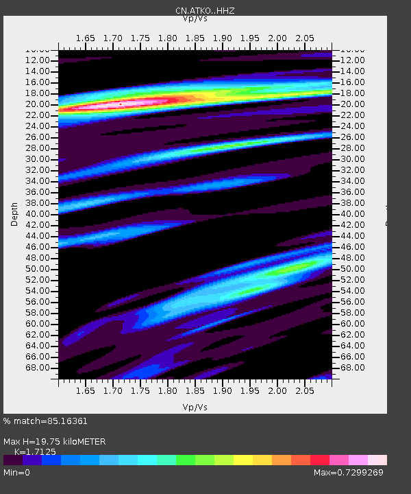
| Estimated Moho Depth: |
19.75 km |
| Estimated Crust Vp/Vs: |
1.71 |
| Assumed Crust Vp: |
6.467 km/s |
| Estimated Crust Vs: |
3.776 km/s |
| Estimated Crust Poisson's Ratio: |
0.24 |
|
| Radial Match: |
85.16361 % |
| Radial Bump: |
349 |
| Transverse Match: |
57.306175 % |
| Transverse Bump: |
400 |
| SOD ConfigId: |
24890451 |
| Insert Time: |
2021-06-02 16:30:51.785 +0000 |
| GWidth: |
2.5 |
| Max Bumps: |
400 |
| Tol: |
0.001 |
|

Signal To Noise
| Channel | StoN | STA | LTA |
| CN:ATKO: :HHZ:20210514T00:09:58.089983Z | 7.013765 | 1.2266387E-6 | 1.7489019E-7 |
| CN:ATKO: :HHN:20210514T00:09:58.089983Z | 3.5341716 | 3.8498737E-7 | 1.0893285E-7 |
| CN:ATKO: :HHE:20210514T00:09:58.089983Z | 6.059993 | 4.908375E-7 | 8.099639E-8 |
| Arrivals |
| Ps | 2.2 SECOND |
| PpPs | 8.1 SECOND |
| PsPs/PpSs | 10 SECOND |


