You are here: Home > Network List > GS - US Geological Survey Networks Stations List
> Station ASA1 ASA1 > Earthquake Result Viewer
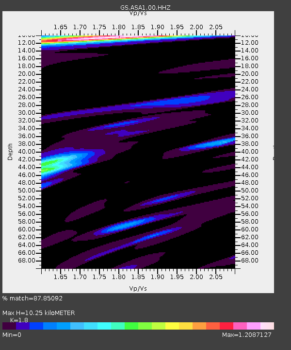
ASA1 ASA1 - Earthquake Result Viewer
| Earthquake location: |
Near East Coast Of Honshu, Japan |
| Earthquake latitude/longitude: |
37.7/141.8 |
| Earthquake time(UTC): |
2021/05/13 (133) 23:58:14 GMT |
| Earthquake Depth: |
32 km |
| Earthquake Magnitude: |
6.0 mww |
| Earthquake Catalog/Contributor: |
NEIC PDE/us |
|
| Network: |
GS US Geological Survey Networks |
| Station: |
ASA1 ASA1 |
| Lat/Lon: |
34.95 N/106.46 W |
| Elevation: |
1829 m |
|
| Distance: |
83.9 deg |
| Az: |
50.107 deg |
| Baz: |
312.204 deg |
| Ray Param: |
0.045796037 |
| Estimated Moho Depth: |
10.25 km |
| Estimated Crust Vp/Vs: |
1.80 |
| Assumed Crust Vp: |
6.502 km/s |
| Estimated Crust Vs: |
3.612 km/s |
| Estimated Crust Poisson's Ratio: |
0.28 |
|
| Radial Match: |
87.85092 % |
| Radial Bump: |
354 |
| Transverse Match: |
79.09441 % |
| Transverse Bump: |
400 |
| SOD ConfigId: |
24890451 |
| Insert Time: |
2021-06-02 16:34:47.239 +0000 |
| GWidth: |
2.5 |
| Max Bumps: |
400 |
| Tol: |
0.001 |
|

Signal To Noise
| Channel | StoN | STA | LTA |
| GS:ASA1:00:HHZ:20210514T00:10:09.628984Z | 4.7560525 | 5.4520643E-7 | 1.1463423E-7 |
| GS:ASA1:00:HH1:20210514T00:10:09.628984Z | 1.0226061 | 7.431905E-8 | 7.267612E-8 |
| GS:ASA1:00:HH2:20210514T00:10:09.628984Z | 1.7881261 | 1.4183813E-7 | 7.932222E-8 |
| Arrivals |
| Ps | 1.3 SECOND |
| PpPs | 4.3 SECOND |
| PsPs/PpSs | 5.6 SECOND |


