You are here: Home > Network List > GS - US Geological Survey Networks Stations List
> Station KAN13 Rinehart Farm > Earthquake Result Viewer
KAN13 Rinehart Farm - Earthquake Result Viewer
*The percent match for this event was below the threshold and hence no stack was calculated.
| Earthquake location: |
Central Mid-Atlantic Ridge |
| Earthquake latitude/longitude: |
-1.1/-23.5 |
| Earthquake time(UTC): |
2017/11/30 (334) 06:32:52 GMT |
| Earthquake Depth: |
10 km |
| Earthquake Magnitude: |
6.5 Mi |
| Earthquake Catalog/Contributor: |
NEIC PDE/at |
|
| Network: |
GS US Geological Survey Networks |
| Station: |
KAN13 Rinehart Farm |
| Lat/Lon: |
37.01 N/97.48 W |
| Elevation: |
340 m |
|
| Distance: |
77.9 deg |
| Az: |
308.113 deg |
| Baz: |
100.648 deg |
| Ray Param: |
$rayparam |
*The percent match for this event was below the threshold and hence was not used in the summary stack. |
|
| Radial Match: |
59.70829 % |
| Radial Bump: |
400 |
| Transverse Match: |
57.548035 % |
| Transverse Bump: |
400 |
| SOD ConfigId: |
2429771 |
| Insert Time: |
2017-12-14 06:37:16.904 +0000 |
| GWidth: |
2.5 |
| Max Bumps: |
400 |
| Tol: |
0.001 |
|
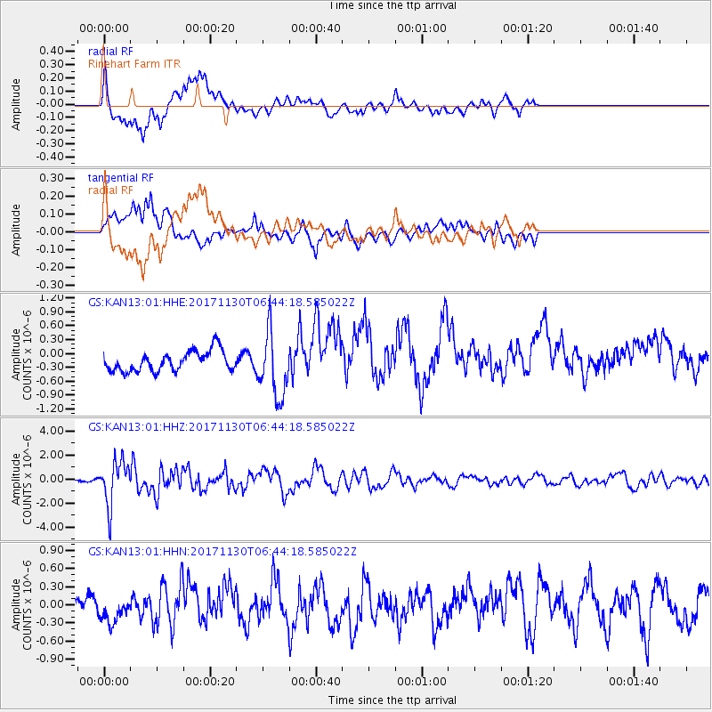
Signal To Noise
| Channel | StoN | STA | LTA |
| GS:KAN13:01:HHZ:20171130T06:44:18.585022Z | 10.794159 | 1.8657474E-6 | 1.7284788E-7 |
| GS:KAN13:01:HHN:20171130T06:44:18.585022Z | 1.3796159 | 2.1287832E-7 | 1.543026E-7 |
| GS:KAN13:01:HHE:20171130T06:44:18.585022Z | 3.2443259 | 7.012766E-7 | 2.1615479E-7 |
| Arrivals |
| Ps | |
| PpPs | |
| PsPs/PpSs | |


