You are here: Home > Network List > OX - North-East Italy Seismic Network Stations List
> Station CIMO Cimolais > Earthquake Result Viewer
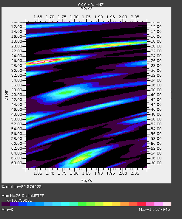
CIMO Cimolais - Earthquake Result Viewer
| Earthquake location: |
Near East Coast Of Honshu, Japan |
| Earthquake latitude/longitude: |
37.7/141.8 |
| Earthquake time(UTC): |
2021/05/13 (133) 23:58:14 GMT |
| Earthquake Depth: |
32 km |
| Earthquake Magnitude: |
6.0 mww |
| Earthquake Catalog/Contributor: |
NEIC PDE/us |
|
| Network: |
OX North-East Italy Seismic Network |
| Station: |
CIMO Cimolais |
| Lat/Lon: |
46.31 N/12.44 E |
| Elevation: |
710 m |
|
| Distance: |
84.8 deg |
| Az: |
327.429 deg |
| Baz: |
38.024 deg |
| Ray Param: |
0.045183286 |
| Estimated Moho Depth: |
26.0 km |
| Estimated Crust Vp/Vs: |
1.68 |
| Assumed Crust Vp: |
6.35 km/s |
| Estimated Crust Vs: |
3.791 km/s |
| Estimated Crust Poisson's Ratio: |
0.22 |
|
| Radial Match: |
82.576225 % |
| Radial Bump: |
383 |
| Transverse Match: |
60.965534 % |
| Transverse Bump: |
400 |
| SOD ConfigId: |
24890451 |
| Insert Time: |
2021-06-02 16:44:38.173 +0000 |
| GWidth: |
2.5 |
| Max Bumps: |
400 |
| Tol: |
0.001 |
|

Signal To Noise
| Channel | StoN | STA | LTA |
| OX:CIMO: :HHZ:20210514T00:10:14.039995Z | 10.060119 | 6.2526385E-7 | 6.215273E-8 |
| OX:CIMO: :HHN:20210514T00:10:14.039995Z | 3.6270998 | 2.121984E-7 | 5.8503606E-8 |
| OX:CIMO: :HHE:20210514T00:10:14.039995Z | 3.3191185 | 2.4661486E-7 | 7.430131E-8 |
| Arrivals |
| Ps | 2.8 SECOND |
| PpPs | 11 SECOND |
| PsPs/PpSs | 14 SECOND |


