You are here: Home > Network List > XH94 - Colorado Plateau-Great Basin Network Stations List
> Station RCC Rock Corral Creek, Utah > Earthquake Result Viewer
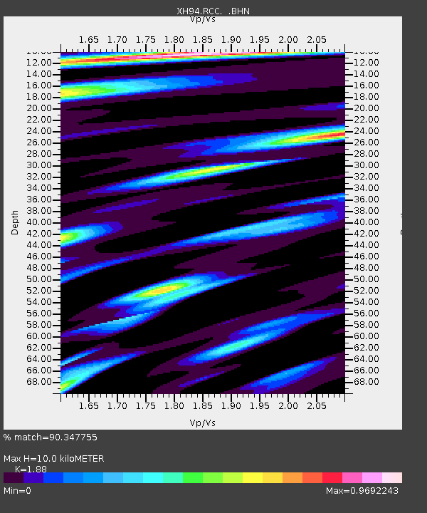
RCC Rock Corral Creek, Utah - Earthquake Result Viewer
| Earthquake location: |
Colombia |
| Earthquake latitude/longitude: |
5.1/-72.9 |
| Earthquake time(UTC): |
1995/01/19 (019) 15:05:03 GMT |
| Earthquake Depth: |
18 km |
| Earthquake Magnitude: |
6.4 MB, 6.6 MS, 6.5 UNKNOWN, 6.5 MW |
| Earthquake Catalog/Contributor: |
WHDF/NEIC |
|
| Network: |
XH Colorado Plateau-Great Basin Network |
| Station: |
RCC Rock Corral Creek, Utah |
| Lat/Lon: |
40.52 N/110.59 W |
| Elevation: |
2280 m |
|
| Distance: |
48.9 deg |
| Az: |
321.781 deg |
| Baz: |
126.063 deg |
| Ray Param: |
0.06906398 |
| Estimated Moho Depth: |
10.0 km |
| Estimated Crust Vp/Vs: |
1.88 |
| Assumed Crust Vp: |
6.155 km/s |
| Estimated Crust Vs: |
3.274 km/s |
| Estimated Crust Poisson's Ratio: |
0.30 |
|
| Radial Match: |
90.347755 % |
| Radial Bump: |
395 |
| Transverse Match: |
71.07125 % |
| Transverse Bump: |
400 |
| SOD ConfigId: |
6273 |
| Insert Time: |
2010-03-09 08:21:11.285 +0000 |
| GWidth: |
2.5 |
| Max Bumps: |
400 |
| Tol: |
0.001 |
|

Signal To Noise
| Channel | StoN | STA | LTA |
| XH:RCC: :BHN:19950119T15:13:17.079004Z | 1.765323 | 3.6505458E-7 | 2.0679194E-7 |
| XH:RCC: :BHE:19950119T15:13:17.079004Z | 2.935903 | 5.1535267E-7 | 1.7553462E-7 |
| XH:RCC: :BHZ:19950119T15:13:17.079004Z | 5.957717 | 1.714424E-6 | 2.8776526E-7 |
| Arrivals |
| Ps | 1.5 SECOND |
| PpPs | 4.4 SECOND |
| PsPs/PpSs | 6.0 SECOND |


